
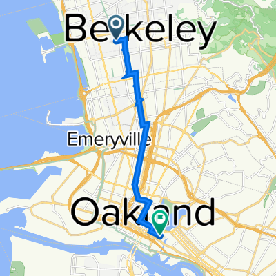
Route template
Berkeley to Oakland

- 37 min
- Duration
- 10.7 km
- Distance
- 83 m
- Ascent
- 110 m
- Descent
- 17.2 km/h
- Avg. speed
- 60 m
- Max. altitude
Looking for a chill Bay Area ride? This route takes you from the heart of Berkeley right into sunny Oakland! It’s about 10.7 km, just long enough to get your legs moving but not so far you’ll be wiped out. You’ll roll mostly on quiet, paved neighborhood streets, gliding past historic bungalows, leafy parks, and a few of those classic Berkeley hills (don’t worry, the climbing isn’t too brutal).
Start near the iconic UC Berkeley campus, known for its vibrant student energy and rich history, then wind your way south through calm residential areas. As you enter Oakland, you’ll notice the scenery shift: murals start popping up and the coffee shops get a little funkier. Downtown Oakland has tons to check out—grab a bite at the eateries or relax at Lake Merritt nearby. All in all, this ride is a sweet, low-traffic cruise connecting two of the Bay’s coolest cultural hubs. Remember your camera!
Community
Top users in this region


From our community
The best bike routes from Berkeley to Oakland

Grizzly to Lake Merrit
Cycling route in Berkeley, California, United States
- 12.4 km
- Distance
- 13 m
- Ascent
- 329 m
- Descent

Recovered Route
Cycling route in Berkeley, California, United States
- 5.9 km
- Distance
- 46 m
- Ascent
- 93 m
- Descent

Allston Way 2001, Berkeley to 13th Street 320, Oakland
Cycling route in Berkeley, California, United States
- 24.6 km
- Distance
- 960 m
- Ascent
- 1,003 m
- Descent

Dunn to Brenner
Cycling route in Berkeley, California, United States
- 5.9 km
- Distance
- 11 m
- Ascent
- 71 m
- Descent

hill bomb to merritt
Cycling route in Berkeley, California, United States
- 26.4 km
- Distance
- 621 m
- Ascent
- 714 m
- Descent


2150 Shattuck Ave, Berkeley to 180 2nd St, Oakland
Cycling route in Berkeley, California, United States
- 10.1 km
- Distance
- 22 m
- Ascent
- 74 m
- Descent

2107 Hearst Ave, Berkeley to 180 2nd St, Oakland
Cycling route in Berkeley, California, United States
- 10.5 km
- Distance
- 54 m
- Ascent
- 114 m
- Descent

2800 Park St, Berkeley to 502–532 Wesley Ave, Oakland
Cycling route in Berkeley, California, United States
- 8.3 km
- Distance
- 45 m
- Ascent
- 51 m
- Descent

5951 College Ave, Oakland to 2311 Ivy Dr, Oakland
Cycling route in Berkeley, California, United States
- 8.2 km
- Distance
- 60 m
- Ascent
- 96 m
- Descent

Allston Way 1409, Berkeley to Fallon Street 900, Oakland
Cycling route in Berkeley, California, United States
- 10 km
- Distance
- 33 m
- Ascent
- 57 m
- Descent

Claremont to Clay Ferry
Cycling route in Berkeley, California, United States
- 9.3 km
- Distance
- 53 m
- Ascent
- 177 m
- Descent
Discover more routes
 hill bomb to merritt
- Distance
- 26.4 km
- Ascent
- 621 m
- Descent
- 714 m
- Location
- Berkeley, California, United States
 Workk
Workk- Distance
- 6.2 km
- Ascent
- 46 m
- Descent
- 48 m
- Location
- Berkeley, California, United States
 2150 Shattuck Ave, Berkeley to 180 2nd St, Oakland
- Distance
- 10.1 km
- Ascent
- 22 m
- Descent
- 74 m
- Location
- Berkeley, California, United States
 2107 Hearst Ave, Berkeley to 180 2nd St, Oakland
- Distance
- 10.5 km
- Ascent
- 54 m
- Descent
- 114 m
- Location
- Berkeley, California, United States
 2800 Park St, Berkeley to 502–532 Wesley Ave, Oakland
- Distance
- 8.3 km
- Ascent
- 45 m
- Descent
- 51 m
- Location
- Berkeley, California, United States
 5951 College Ave, Oakland to 2311 Ivy Dr, Oakland
- Distance
- 8.2 km
- Ascent
- 60 m
- Descent
- 96 m
- Location
- Berkeley, California, United States
 Allston Way 1409, Berkeley to Fallon Street 900, Oakland
- Distance
- 10 km
- Ascent
- 33 m
- Descent
- 57 m
- Location
- Berkeley, California, United States
 Claremont to Clay Ferry
- Distance
- 9.3 km
- Ascent
- 53 m
- Descent
- 177 m
- Location
- Berkeley, California, United States
Routes from Berkeley
Quick ride by bicycle from
Berkeley to Piedmont
Quick ride by bicycle from
Berkeley to Emeryville