
Cycling day trip from Sarrià-Sant Gervasi to Sant Cugat del Vallès
Customize your own route based on our template or discover how our community prefers to cycle from Sarrià-Sant Gervasi to Sant Cugat del Vallès.
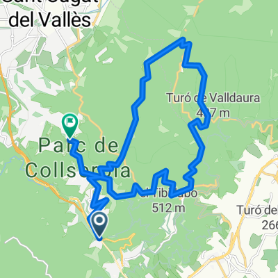
Route template
Sarrià-Sant Gervasi to Sant Cugat del Vallès

- 2 h 2 min
- Duration
- 32.1 km
- Distance
- 226 m
- Ascent
- 225 m
- Descent
- 15.8 km/h
- Avg. speed
- 125 m
- Max. altitude
This ride takes you from the leafy neighborhood of Sarrià-Sant Gervasi in Barcelona up to the charming town of Sant Cugat del Vallès. It’s a solid 32 km stretch with a little over 225 meters of climbing, but nothing too punishing—just enough to keep things interesting. Most of the route is on well-paved cycleways and quiet roads, with minimal car traffic, making it a relaxed and enjoyable ride.
You’ll start off near the Collserola hills, a green escape from the city bustle. Sarrià-Sant Gervasi itself is known for its elegant streets and proximity to the Parc Natural de la Serra de Collserola—a perfect gateway for many local cyclists. As you pedal north, you’ll get to soak in some great views and enjoy a mix of urban and natural scenery.
Finishing in Sant Cugat, you’re greeted by a picturesque old town and its famous Romanesque monastery. It’s a popular cycling destination, with plenty of cafés for a well-deserved break. All in all, a lovely ride through some of the best green spaces on Barcelona’s doorstep!
Community
Top users in this region


From our community
The best bike routes from Sarrià-Sant Gervasi to Sant Cugat del Vallès

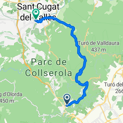
Passatge de les aigues + Sol I Aigua + Can Coll + San Cugat
Cycling route in Sarrià-Sant Gervasi, Catalonia, Spain
- 22.4 km
- Distance
- 434 m
- Ascent
- 571 m
- Descent

Baixador de Vallvidrera - Tibidabo - Can Coll - Can Borell - VDX
Cycling route in Sarrià-Sant Gervasi, Catalonia, Spain
- 27 km
- Distance
- 505 m
- Ascent
- 608 m
- Descent

ACUEDUCTO
Cycling route in Sarrià-Sant Gervasi, Catalonia, Spain
- 3.4 km
- Distance
- 30 m
- Ascent
- 283 m
- Descent

vallvidrera a la floresta
Cycling route in Sarrià-Sant Gervasi, Catalonia, Spain
- 7.4 km
- Distance
- 154 m
- Ascent
- 291 m
- Descent

Passatge de les aigues + Sol I Aigua + Can Coll + San Cugat
Cycling route in Sarrià-Sant Gervasi, Catalonia, Spain
- 22.4 km
- Distance
- 416 m
- Ascent
- 557 m
- Descent

Baixador-Les Planes-Sol i aire-can borrel-volta fins la font groga-Les Planes-La floresta
Cycling route in Sarrià-Sant Gervasi, Catalonia, Spain
- 22.5 km
- Distance
- 632 m
- Ascent
- 622 m
- Descent

walking to st cugat
Cycling route in Sarrià-Sant Gervasi, Catalonia, Spain
- 12.1 km
- Distance
- 137 m
- Ascent
- 372 m
- Descent

bcn-santcu
Cycling route in Sarrià-Sant Gervasi, Catalonia, Spain
- 11 km
- Distance
- 193 m
- Ascent
- 348 m
- Descent

Tibidabo_Tramo 2.gpx
Cycling route in Sarrià-Sant Gervasi, Catalonia, Spain
- 3.9 km
- Distance
- 112 m
- Ascent
- 291 m
- Descent

Vallvidrera-Sant Cugat
Cycling route in Sarrià-Sant Gervasi, Catalonia, Spain
- 10.7 km
- Distance
- 139 m
- Ascent
- 416 m
- Descent

Yeeaaa
Cycling route in Sarrià-Sant Gervasi, Catalonia, Spain
- 9 km
- Distance
- 299 m
- Ascent
- 360 m
- Descent

Collserola
Cycling route in Sarrià-Sant Gervasi, Catalonia, Spain
- 13.5 km
- Distance
- 342 m
- Ascent
- 571 m
- Descent
Discover more routes
 Passatge de les aigues + Sol I Aigua + Can Coll + San Cugat
- Distance
- 22.4 km
- Ascent
- 416 m
- Descent
- 557 m
- Location
- Sarrià-Sant Gervasi, Catalonia, Spain
 Baixador-Les Planes-Sol i aire-can borrel-volta fins la font groga-Les Planes-La floresta
- Distance
- 22.5 km
- Ascent
- 632 m
- Descent
- 622 m
- Location
- Sarrià-Sant Gervasi, Catalonia, Spain
 walking to st cugat
- Distance
- 12.1 km
- Ascent
- 137 m
- Descent
- 372 m
- Location
- Sarrià-Sant Gervasi, Catalonia, Spain
 bcn-santcu
- Distance
- 11 km
- Ascent
- 193 m
- Descent
- 348 m
- Location
- Sarrià-Sant Gervasi, Catalonia, Spain
 Tibidabo_Tramo 2.gpx
- Distance
- 3.9 km
- Ascent
- 112 m
- Descent
- 291 m
- Location
- Sarrià-Sant Gervasi, Catalonia, Spain
 Vallvidrera-Sant Cugat
- Distance
- 10.7 km
- Ascent
- 139 m
- Descent
- 416 m
- Location
- Sarrià-Sant Gervasi, Catalonia, Spain
 Yeeaaa
- Distance
- 9 km
- Ascent
- 299 m
- Descent
- 360 m
- Location
- Sarrià-Sant Gervasi, Catalonia, Spain
 Collserola
- Distance
- 13.5 km
- Ascent
- 342 m
- Descent
- 571 m
- Location
- Sarrià-Sant Gervasi, Catalonia, Spain
Routes from Sarrià-Sant Gervasi
Quick ride by bicycle from
Sarrià-Sant Gervasi to Les Corts