How cycling in Măneciu-Ungureni could look like.
How cycling in Slon could look like.

Quick ride by bicycle from Măneciu-Ungureni to Slon

Customize your own route based on our template or discover how our community prefers to cycle from Măneciu-Ungureni to Slon.

Route template

Măneciu-Ungureni to Slon

1 h 31 min
Duration
19.5 km
Distance
609 m
Ascent
594 m
Descent
12.9 km/h
Avg. speed
881 m
Max. altitude

This ride starts in Măneciu-Ungureni, a peaceful mountain village nestled by Lake Măneciu and known for its fresh air and lush landscapes. You’ll be cycling north-east toward Slon, a small, traditional village perched at the foot of the Ciucaș Mountains.

The 19.5 km route is quite varied: expect to climb and descend a total of about 600 meters each way as you wind through hilly terrain—great for anyone looking for scenic views and a bit of a challenge. Most of your journey takes place on quiet country roads and tracks (with hardly any busy roads to worry about), but keep in mind that about 60% of the surfaces are either gravel, dirt, or otherwise unpaved—so a gravel or mountain bike will feel at home here.

The area is famous for its natural beauty and rural charm; take your time, soak up the tranquil vibe, and enjoy some classic Romanian countryside along the way. Once you reach Slon, you might spot the picturesque rolling meadows and forests that make this region a hidden gem for cyclists.

Community

Top users in this region

From our community

The best bike routes from Măneciu-Ungureni to Slon

3

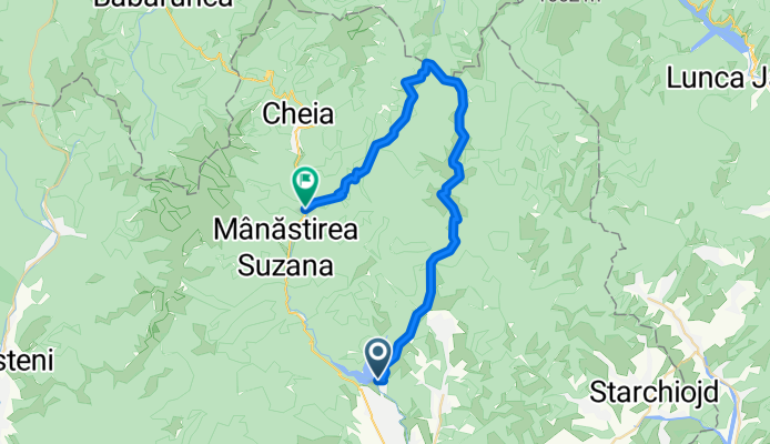
Traseul Muntilor Tataru

Cycling route in Măneciu-Ungureni, Prahova, Romania

Tataru Mountains Route: Maneciu Ungureni Train Station - Valea Larga - Maneciu Reservoir - Chiciureni Peak - Slonului Hill - Varful lui Crai - Tabla Butii - Boncuta Pass - Stanii Valley - Triangle - Schinda - Maneciu Reservoir
47.6 km
Distance
1,168 m
Ascent
926 m
Descent
1

MTB / Triatlon Maneciu - Cerasu

Cycling route in Măneciu-Ungureni, Prahova, Romania

Mâneciu Dam - Schinda - Plai Slon
17.6 km
Distance
579 m
Ascent
329 m
Descent
0

Traseu Triatlon Fara Asfalt la munte

Cycling route in Măneciu-Ungureni, Prahova, Romania

Unpaved Mountain Triathlon Route
20.5 km
Distance
661 m
Ascent
387 m
Descent
0

Valea Popii(Pleșu)-Clăbucet

Cycling route in Măneciu-Ungureni, Prahova, Romania

Valea Popii (Pleșu)-Clăbucet prin stâna din Clăbucet (bulina galbenă)
6.6 km
Distance
715 m
Ascent
44 m
Descent
1

Baraj Maneciu- Pasul Boncuta-DN1A

Cycling route in Măneciu-Ungureni, Prahova, Romania

36.9 km
Distance
1,061 m
Ascent
877 m
Descent
0

Maneciu-Vf Lui Crai

Cycling route in Măneciu-Ungureni, Prahova, Romania

Begin at the crown of the Maneciu Dam on the road that rises to the right. Superb views along the entire route. At km 5, turn right (the road to the left descends to Telejenel), and at km 7, turn left (the road to the right descends to Slon).
15.4 km
Distance
936 m
Ascent
60 m
Descent
1

Fara asfalt

Cycling route in Măneciu-Ungureni, Prahova, Romania

42.6 km
Distance
1,105 m
Ascent
952 m
Descent
1

triatlon fara asfalt

Cycling route in Măneciu-Ungureni, Prahova, Romania

20.6 km
Distance
530 m
Ascent
265 m
Descent
0

drumeție 1

Cycling route in Măneciu-Ungureni, Prahova, Romania

20.5 km
Distance
469 m
Ascent
172 m
Descent
0

Maneciu - Tabla Butii - Slon

Cycling route in Măneciu-Ungureni, Prahova, Romania

43.7 km
Distance
1,088 m
Ascent
1,076 m
Descent
0

Plimbare

Cycling route in Măneciu-Ungureni, Prahova, Romania

7.1 km
Distance
463 m
Ascent
113 m
Descent
0

Valea Popii-Clăbucet

Cycling route in Măneciu-Ungureni, Prahova, Romania

Valea Popii-Clăbucet (bulina galbena)
5.1 km
Distance
628 m
Ascent
79 m
Descent

Discover more routes