
Quick ride by bicycle from Stuttgart-Ost to Fellbach
Customize your own route based on our template or discover how our community prefers to cycle from Stuttgart-Ost to Fellbach.
Route template
Stuttgart-Ost to Fellbach
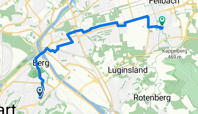
- 32 min
- Duration
- 9 km
- Distance
- 91 m
- Ascent
- 60 m
- Descent
- 16.9 km/h
- Avg. speed
- 304 m
- Max. altitude
This leisurely 9 km ride starts in Stuttgart-Ost, a leafy neighborhood known for its historic architecture and proximity to downtown Stuttgart. You’ll roll out mostly on quiet streets and smooth asphalts—perfect for a relaxed pace, with just enough gentle climbs (about 90 meters) to get your heart pumping without breaking a sweat.
As you wind northeast, you’ll pass through mixed scenery—think a dash of urban green, charming residential pockets, and the occasional glimpse of Stuttgart’s hillside vineyards. The route is paved all the way, with the vast majority on asphalt and sprinkled with a few short sections of paving stones and cobblestone to keep it interesting.
You’ll finish in Fellbach, a lively town just outside Stuttgart, famous for its wine culture and annual autumn wine festival. It’s a great spot to stop for a coffee or glass of local Riesling. Whether you’re commuting or just out for a refreshing pedal, this route is city cycling at its best—scenic, straightforward, and stress-free.
Community
Top users in this region


From our community
The best bike routes from Stuttgart-Ost to Fellbach

Bad Cannstatt - Welzheim
Cycling route in Stuttgart-Ost, Baden-Wurttemberg, Germany
- 98.4 km
- Distance
- 1,357 m
- Ascent
- 1,329 m
- Descent

BC Loop (A) - 51K
Cycling route in Stuttgart-Ost, Baden-Wurttemberg, Germany
- 51.6 km
- Distance
- 391 m
- Ascent
- 372 m
- Descent

UT_Sigurdweg
Cycling route in Stuttgart-Ost, Baden-Wurttemberg, Germany
- 2.5 km
- Distance
- 69 m
- Ascent
- 7 m
- Descent

Wiesbadener Straße 76, Stuttgart nach Düsseldorfer Straße 18, Waiblingen
Cycling route in Stuttgart-Ost, Baden-Wurttemberg, Germany
- 6.6 km
- Distance
- 72 m
- Ascent
- 38 m
- Descent

20150109_051635.gpx
Cycling route in Stuttgart-Ost, Baden-Wurttemberg, Germany
- 9.9 km
- Distance
- 319 m
- Ascent
- 41 m
- Descent

BC Loop (A) - 51K
Cycling route in Stuttgart-Ost, Baden-Wurttemberg, Germany
- 51.6 km
- Distance
- 398 m
- Ascent
- 388 m
- Descent

Mercedesstraße 137, Stuttgart nach Flandernstraße 4, Stuttgart
Cycling route in Stuttgart-Ost, Baden-Wurttemberg, Germany
- 4 km
- Distance
- 62 m
- Ascent
- 4 m
- Descent

Mercedes-Jellinek-Straße, Stuttgart nach Flandernstraße 4, Stuttgart
Cycling route in Stuttgart-Ost, Baden-Wurttemberg, Germany
- 4.2 km
- Distance
- 65 m
- Ascent
- 9 m
- Descent

détendu dimanche vignes grabklappelle 1 allée
Cycling route in Stuttgart-Ost, Baden-Wurttemberg, Germany
- 7.8 km
- Distance
- 206 m
- Ascent
- 70 m
- Descent

platten_01
Cycling route in Stuttgart-Ost, Baden-Wurttemberg, Germany
- 12.9 km
- Distance
- 377 m
- Ascent
- 335 m
- Descent

Carsten 1
Cycling route in Stuttgart-Ost, Baden-Wurttemberg, Germany
- 14.3 km
- Distance
- 327 m
- Ascent
- 331 m
- Descent

BSG-schoenbuehl
Cycling route in Stuttgart-Ost, Baden-Wurttemberg, Germany
- 54.3 km
- Distance
- 506 m
- Ascent
- 429 m
- Descent
Discover more routes
 20150109_051635.gpx
- Distance
- 9.9 km
- Ascent
- 319 m
- Descent
- 41 m
- Location
- Stuttgart-Ost, Baden-Wurttemberg, Germany
 BC Loop (A) - 51K
- Distance
- 51.6 km
- Ascent
- 398 m
- Descent
- 388 m
- Location
- Stuttgart-Ost, Baden-Wurttemberg, Germany
 Mercedesstraße 137, Stuttgart nach Flandernstraße 4, Stuttgart
- Distance
- 4 km
- Ascent
- 62 m
- Descent
- 4 m
- Location
- Stuttgart-Ost, Baden-Wurttemberg, Germany
 Mercedes-Jellinek-Straße, Stuttgart nach Flandernstraße 4, Stuttgart
- Distance
- 4.2 km
- Ascent
- 65 m
- Descent
- 9 m
- Location
- Stuttgart-Ost, Baden-Wurttemberg, Germany
 détendu dimanche vignes grabklappelle 1 allée
- Distance
- 7.8 km
- Ascent
- 206 m
- Descent
- 70 m
- Location
- Stuttgart-Ost, Baden-Wurttemberg, Germany
 platten_01
- Distance
- 12.9 km
- Ascent
- 377 m
- Descent
- 335 m
- Location
- Stuttgart-Ost, Baden-Wurttemberg, Germany
 Carsten 1
- Distance
- 14.3 km
- Ascent
- 327 m
- Descent
- 331 m
- Location
- Stuttgart-Ost, Baden-Wurttemberg, Germany
 BSG-schoenbuehl
- Distance
- 54.3 km
- Ascent
- 506 m
- Descent
- 429 m
- Location
- Stuttgart-Ost, Baden-Wurttemberg, Germany
Routes from Stuttgart-Ost
Quick ride by bicycle from
Stuttgart-Ost to Stuttgart
Quick ride by bicycle from
Stuttgart-Ost to Esslingen am Neckar