
Cycling day trip from Ždiar to Vysoké Tatry
Customize your own route based on our template or discover how our community prefers to cycle from Ždiar to Vysoké Tatry.
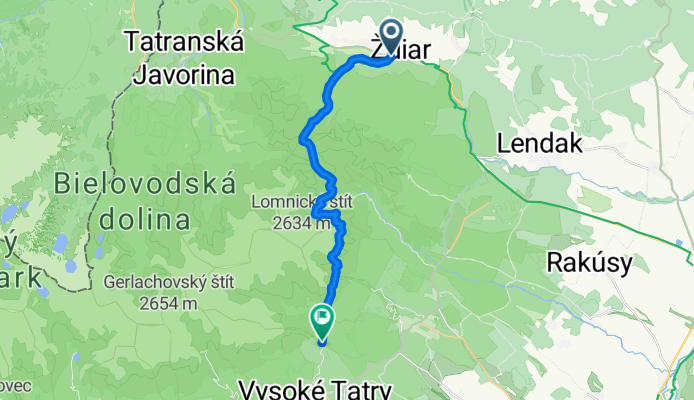
Route template
Ždiar to Vysoké Tatry

- 1 h 58 min
- Duration
- 27 km
- Distance
- 580 m
- Ascent
- 565 m
- Descent
- 13.7 km/h
- Avg. speed
- 930 m
- Max. altitude
This scenic ride whisks you from the charming mountain village of Ždiar—famous for its traditional wooden architecture and sweeping views of the Belianske Tatras—down to Vysoké Tatry, the heart of Slovakia’s most iconic mountain region. Covering just under 27 km, it’s a route that’ll excite any cyclist who loves a mix of adventure and serene alpine beauty.
Be ready for some elevation: you’ll climb nearly 580 meters and descend just a little less, with plenty of sections on lovely (mostly paved) roads, plus a good chunk of gravel and looser paths—perfect for a gravel bike or a sturdy hybrid.
As you roll south, pine forests and open meadows alternate with mountain vistas that’ll have you stopping for photos. Arriving in Vysoké Tatry, you’ll find yourself at the gateway to the High Tatras National Park, a favorite destination for hikers and nature lovers.
Pack a snack, take it steady on the descents, and enjoy Slovakia’s mountain air—this ride is a stunner from start to finish!
Community
Top users in this region


From our community
The best bike routes from Ždiar to Vysoké Tatry

Túra Zelené pleso
Cycling route in Ždiar, Prešov Region, Slovakia
- 7.4 km
- Distance
- 22 m
- Ascent
- 645 m
- Descent

2014_10 Ždiar_Tatranská Lomnica pěšky
Cycling route in Ždiar, Prešov Region, Slovakia
- 21.9 km
- Distance
- 1,125 m
- Ascent
- 1,148 m
- Descent

2018_10 přes Belanské Tatry pěšky
Cycling route in Ždiar, Prešov Region, Slovakia
- 15.6 km
- Distance
- 999 m
- Ascent
- 1,096 m
- Descent

2009_09 Tatranská Javorina_Tatranská Lomnica pěšky
Cycling route in Ždiar, Prešov Region, Slovakia
- 23.3 km
- Distance
- 1,491 m
- Ascent
- 1,671 m
- Descent

2011_10 Lysá Poľana_Polský hrebeň_Starý Smokovec pěšky
Cycling route in Ždiar, Prešov Region, Slovakia
- 24.4 km
- Distance
- 1,451 m
- Ascent
- 1,442 m
- Descent

Jahňací štít
Cycling route in Ždiar, Prešov Region, Slovakia
- 12.5 km
- Distance
- 623 m
- Ascent
- 1,247 m
- Descent

2011_09 Ždiar_Biela Voda pěšky
Cycling route in Ždiar, Prešov Region, Slovakia
- 16.9 km
- Distance
- 1,130 m
- Ascent
- 1,086 m
- Descent

Ždiar - M.Poľana (Bachledova) - Lendak - Tatr.Lomnica - Štart
Cycling route in Ždiar, Prešov Region, Slovakia
- 34.7 km
- Distance
- 900 m
- Ascent
- 599 m
- Descent

Tatranska Javorina - Vysoke Tatry
Cycling route in Ždiar, Prešov Region, Slovakia
- 21.4 km
- Distance
- 1,364 m
- Ascent
- 1,351 m
- Descent

Berghütte am Grünen Bergsee - Zamkovsky Hütte
Cycling route in Ždiar, Prešov Region, Slovakia
- 8.3 km
- Distance
- 528 m
- Ascent
- 596 m
- Descent

Hohe Tatra 2.Tag
Cycling route in Ždiar, Prešov Region, Slovakia
- 20.5 km
- Distance
- 774 m
- Ascent
- 847 m
- Descent
Discover more routes
 2011_10 Lysá Poľana_Polský hrebeň_Starý Smokovec pěšky
- Distance
- 24.4 km
- Ascent
- 1,451 m
- Descent
- 1,442 m
- Location
- Ždiar, Prešov Region, Slovakia
 Jahňací štít
- Distance
- 12.5 km
- Ascent
- 623 m
- Descent
- 1,247 m
- Location
- Ždiar, Prešov Region, Slovakia
 2011_09 Ždiar_Biela Voda pěšky
- Distance
- 16.9 km
- Ascent
- 1,130 m
- Descent
- 1,086 m
- Location
- Ždiar, Prešov Region, Slovakia
 Ždiar - M.Poľana (Bachledova) - Lendak - Tatr.Lomnica - Štart
- Distance
- 34.7 km
- Ascent
- 900 m
- Descent
- 599 m
- Location
- Ždiar, Prešov Region, Slovakia
 Tatranska Javorina - Vysoke Tatry
- Distance
- 21.4 km
- Ascent
- 1,364 m
- Descent
- 1,351 m
- Location
- Ždiar, Prešov Region, Slovakia
 Berghütte am Grünen Bergsee - Zamkovsky Hütte
- Distance
- 8.3 km
- Ascent
- 528 m
- Descent
- 596 m
- Location
- Ždiar, Prešov Region, Slovakia
 Hohe Tatra 2.Tag
- Distance
- 20.5 km
- Ascent
- 774 m
- Descent
- 847 m
- Location
- Ždiar, Prešov Region, Slovakia
 turistika
- Distance
- 18 km
- Ascent
- 1,648 m
- Descent
- 1,253 m
- Location
- Ždiar, Prešov Region, Slovakia
Routes from Ždiar
Cycling day trip from
Ždiar to Zakopane
Routes to Vysoké Tatry
Cycling day trip from
Strba to Vysoké Tatry
Cycling day trip from
Liptovský Mikuláš to Vysoké Tatry
Quick ride by bicycle from
Poprad to Vysoké Tatry
Quick ride by bicycle from
Nová Lesná to Vysoké Tatry