
Route template
Tyczyn to Rzeszów
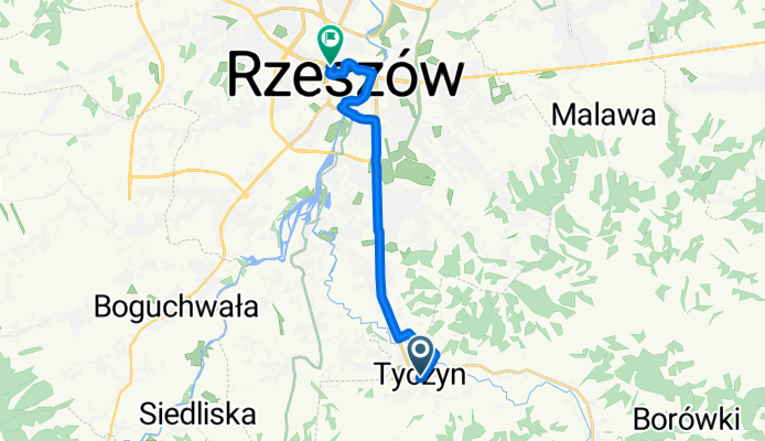
- 43 min
- Duration
- 12.7 km
- Distance
- 25 m
- Ascent
- 49 m
- Descent
- 17.8 km/h
- Avg. speed
- 233 m
- Max. altitude
This relaxed ride starts in Tyczyn, a small but charming town known for its historical market square and quiet atmosphere. From there, you’ll pedal north towards Rzeszów, the bustling regional capital of southeastern Poland. The route is just over 12.5 km and mostly flat, making it a comfortable choice for most cyclists.
You’ll mostly cruise along paved or asphalt surfaces—so your ride will be smooth, with only a few sections of paving stones or concrete to keep things interesting. The majority of the route follows quiet roads and dedicated cycle paths, so you can enjoy the scenery with minimal traffic stress. With just a gentle ascent of 25 meters and a bit more in descent, you’ll find it’s an easy trip overall.
Once you reach Rzeszów, reward yourself by exploring the vibrant city centre, with its lovely Main Square and historic tenement houses. Perfect for a morning ride or a leisurely weekend spin!
Community
Top users in this region


From our community
The best bike routes from Tyczyn to Rzeszów

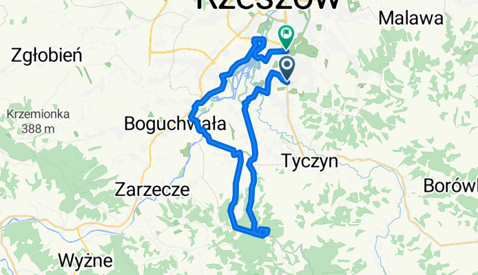
Dookola Patrii
Cycling route in Tyczyn, Subcarpathian Voivodeship, Poland
- 63 km
- Distance
- 660 m
- Ascent
- 682 m
- Descent
Zalesie- Przylasek- Boguchwała- Lisia góra
Cycling route in Tyczyn, Subcarpathian Voivodeship, Poland
- 30.5 km
- Distance
- 252 m
- Ascent
- 256 m
- Descent

Dookola Patrii
Cycling route in Tyczyn, Subcarpathian Voivodeship, Poland
- 63 km
- Distance
- 619 m
- Ascent
- 644 m
- Descent

18.06 okolice z Misią
Cycling route in Tyczyn, Subcarpathian Voivodeship, Poland
- 18.6 km
- Distance
- 303 m
- Ascent
- 361 m
- Descent

Rzeszów_Chmielnik_Magdalenka_Rzeszów
Cycling route in Tyczyn, Subcarpathian Voivodeship, Poland
- 35.2 km
- Distance
- 578 m
- Ascent
- 593 m
- Descent

Potoki 44, Tyczyn do Zalesie, Rzeszów
Cycling route in Tyczyn, Subcarpathian Voivodeship, Poland
- 14.7 km
- Distance
- 34 m
- Ascent
- 83 m
- Descent

26.06
Cycling route in Tyczyn, Subcarpathian Voivodeship, Poland
- 31.1 km
- Distance
- 633 m
- Ascent
- 641 m
- Descent

Aleja Generała Władysława Sikorskiego 292, Biała do Eugeniusza Kwiatkowskiego 46C, Rzeszów
Cycling route in Tyczyn, Subcarpathian Voivodeship, Poland
- 10.3 km
- Distance
- 95 m
- Ascent
- 114 m
- Descent
Tyczyn
Cycling route in Tyczyn, Subcarpathian Voivodeship, Poland
- 6.9 km
- Distance
- 186 m
- Ascent
- 166 m
- Descent

hadle 1
Cycling route in Tyczyn, Subcarpathian Voivodeship, Poland
- 70.7 km
- Distance
- 634 m
- Ascent
- 648 m
- Descent

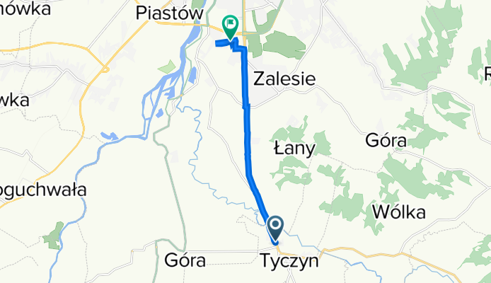
Rodzinna 90, Tyczyn do Kępa 3–7, Rzeszów
Cycling route in Tyczyn, Subcarpathian Voivodeship, Poland
- 7.3 km
- Distance
- 19 m
- Ascent
- 176 m
- Descent

Semafor
Cycling route in Tyczyn, Subcarpathian Voivodeship, Poland
- 69.4 km
- Distance
- 446 m
- Ascent
- 565 m
- Descent
Discover more routes
 Rzeszów_Chmielnik_Magdalenka_Rzeszów
- Distance
- 35.2 km
- Ascent
- 578 m
- Descent
- 593 m
- Location
- Tyczyn, Subcarpathian Voivodeship, Poland
 Potoki 44, Tyczyn do Zalesie, Rzeszów
- Distance
- 14.7 km
- Ascent
- 34 m
- Descent
- 83 m
- Location
- Tyczyn, Subcarpathian Voivodeship, Poland
 26.06
26.06- Distance
- 31.1 km
- Ascent
- 633 m
- Descent
- 641 m
- Location
- Tyczyn, Subcarpathian Voivodeship, Poland
 Aleja Generała Władysława Sikorskiego 292, Biała do Eugeniusza Kwiatkowskiego 46C, Rzeszów
- Distance
- 10.3 km
- Ascent
- 95 m
- Descent
- 114 m
- Location
- Tyczyn, Subcarpathian Voivodeship, Poland
 Tyczyn
- Distance
- 6.9 km
- Ascent
- 186 m
- Descent
- 166 m
- Location
- Tyczyn, Subcarpathian Voivodeship, Poland
 hadle 1
- Distance
- 70.7 km
- Ascent
- 634 m
- Descent
- 648 m
- Location
- Tyczyn, Subcarpathian Voivodeship, Poland
 Rodzinna 90, Tyczyn do Kępa 3–7, Rzeszów
- Distance
- 7.3 km
- Ascent
- 19 m
- Descent
- 176 m
- Location
- Tyczyn, Subcarpathian Voivodeship, Poland
 Semafor
- Distance
- 69.4 km
- Ascent
- 446 m
- Descent
- 565 m
- Location
- Tyczyn, Subcarpathian Voivodeship, Poland
Routes to Rzeszów
Cycling day trip from
Przemyśl to Rzeszów
Quick ride by bicycle from
Boguchwała to Rzeszów