
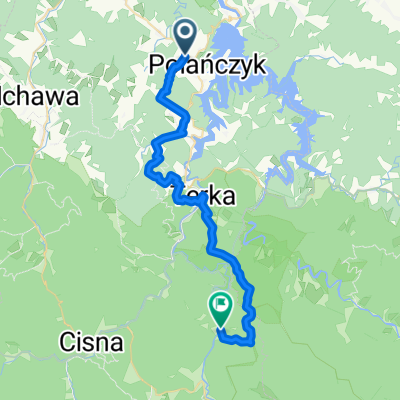
Route template
Polańczyk to Cisna

- 2 h 11 min
- Duration
- 29.7 km
- Distance
- 959 m
- Ascent
- 888 m
- Descent
- 13.6 km/h
- Avg. speed
- 825 m
- Max. altitude
Get ready for a stunning adventure through the scenic heart of the Bieszczady Mountains! Your ride begins in Polańczyk, a laid-back lakeside village known for its spa vibe and panoramic views of Lake Solina—it's a favorite with both cyclists and water lovers.
Heading south, you’ll follow mostly paved roads with a few sections of classic asphalt, winding up and down through forested hills and wide-open meadows. Don't be surprised by the almost 1,000 meters of climbing; it’s all part of the charm. The route mixes stretches of busier roads with quieter byways, giving you a nice balance of flow and solitude.
After about 30 km of fresh mountain air, you’ll roll into Cisna. This village is a legendary stop for hikers and bikers tackling the Bieszczady, complete with cozy mountain cafés and a laid-back, artistic vibe. If you have the time, grab a homemade snack and soak in the peaceful surroundings—you’ve earned it!
Community
Top users in this region


From our community
The best bike routes from Polańczyk to Cisna

Wycieczka po Bieszczadach
Cycling route in Polańczyk, Subcarpathian Voivodeship, Poland
- 16.8 km
- Distance
- 292 m
- Ascent
- 166 m
- Descent

TdB 09 - dzień 4 (Wołkowyje-Strzebowiska)
Cycling route in Polańczyk, Subcarpathian Voivodeship, Poland
- 32.9 km
- Distance
- 468 m
- Ascent
- 218 m
- Descent

Jaworzec
Cycling route in Polańczyk, Subcarpathian Voivodeship, Poland
- 28.8 km
- Distance
- 501 m
- Ascent
- 430 m
- Descent

2. Solina - Kalnica, 30.06.2009
Cycling route in Polańczyk, Subcarpathian Voivodeship, Poland
- 37 km
- Distance
- 884 m
- Ascent
- 679 m
- Descent

2011.08.22- Terka- Wetlina
Cycling route in Polańczyk, Subcarpathian Voivodeship, Poland
- 102.3 km
- Distance
- 1,092 m
- Ascent
- 911 m
- Descent

Polańczyk - Rajskie - Czarna Górna - Lutowiska - Ustrzyki Górne - Wetlina
Cycling route in Polańczyk, Subcarpathian Voivodeship, Poland
- 82.7 km
- Distance
- 1,238 m
- Ascent
- 1,043 m
- Descent

7 dzień - Wołkowyja - Cisna - 71 km.
Cycling route in Polańczyk, Subcarpathian Voivodeship, Poland
- 71 km
- Distance
- 0 m
- Ascent
- 0 m
- Descent

Wiejska 3, Polańczyk do Wetlina 22, Cisna
Cycling route in Polańczyk, Subcarpathian Voivodeship, Poland
- 32.4 km
- Distance
- 1,497 m
- Ascent
- 1,362 m
- Descent

2. Wołkowyja - Żubracze
Cycling route in Polańczyk, Subcarpathian Voivodeship, Poland
- 49 km
- Distance
- 983 m
- Ascent
- 779 m
- Descent

Dzien 1 do Schr. "Jaworzec"
Cycling route in Polańczyk, Subcarpathian Voivodeship, Poland
- 31.9 km
- Distance
- 1,110 m
- Ascent
- 995 m
- Descent

Wielka Petla Bieszczadzka - dzień 1
Cycling route in Polańczyk, Subcarpathian Voivodeship, Poland
- 92.4 km
- Distance
- 1,098 m
- Ascent
- 847 m
- Descent

Camino Sud 2
Cycling route in Polańczyk, Subcarpathian Voivodeship, Poland
- 34.5 km
- Distance
- 555 m
- Ascent
- 320 m
- Descent
Discover more routes
 2011.08.22- Terka- Wetlina
- Distance
- 102.3 km
- Ascent
- 1,092 m
- Descent
- 911 m
- Location
- Polańczyk, Subcarpathian Voivodeship, Poland
 Polańczyk - Rajskie - Czarna Górna - Lutowiska - Ustrzyki Górne - Wetlina
- Distance
- 82.7 km
- Ascent
- 1,238 m
- Descent
- 1,043 m
- Location
- Polańczyk, Subcarpathian Voivodeship, Poland
 7 dzień - Wołkowyja - Cisna - 71 km.
- Distance
- 71 km
- Ascent
- 0 m
- Descent
- 0 m
- Location
- Polańczyk, Subcarpathian Voivodeship, Poland
 Wiejska 3, Polańczyk do Wetlina 22, Cisna
- Distance
- 32.4 km
- Ascent
- 1,497 m
- Descent
- 1,362 m
- Location
- Polańczyk, Subcarpathian Voivodeship, Poland
 2. Wołkowyja - Żubracze
- Distance
- 49 km
- Ascent
- 983 m
- Descent
- 779 m
- Location
- Polańczyk, Subcarpathian Voivodeship, Poland
 Dzien 1 do Schr. "Jaworzec"
- Distance
- 31.9 km
- Ascent
- 1,110 m
- Descent
- 995 m
- Location
- Polańczyk, Subcarpathian Voivodeship, Poland
 Wielka Petla Bieszczadzka - dzień 1
- Distance
- 92.4 km
- Ascent
- 1,098 m
- Descent
- 847 m
- Location
- Polańczyk, Subcarpathian Voivodeship, Poland
 Camino Sud 2
- Distance
- 34.5 km
- Ascent
- 555 m
- Descent
- 320 m
- Location
- Polańczyk, Subcarpathian Voivodeship, Poland
Routes to Cisna
Cycling day trip from
Lutowiska to Cisna