
Route template
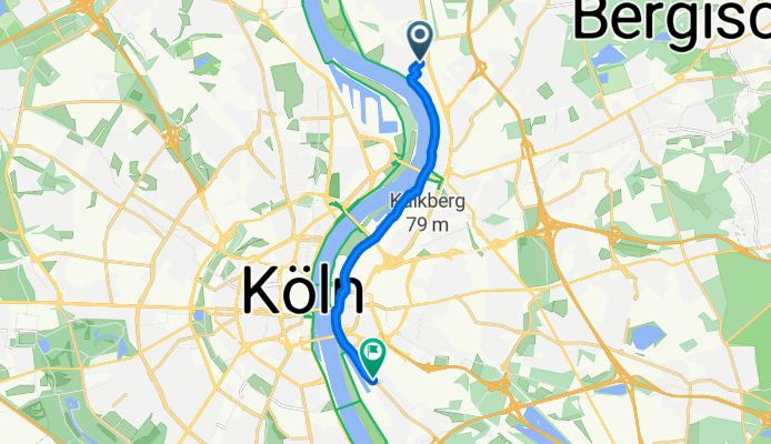
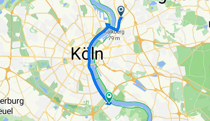
Mülheim to Poll

- 33 min
- Duration
- 8.7 km
- Distance
- 37 m
- Ascent
- 40 m
- Descent
- 15.6 km/h
- Avg. speed
- 56 m
- Max. altitude
This cycling route takes you from Mülheim, a vibrant district on the right bank of the Rhine in Cologne, down to Poll, a more laid-back neighborhood known for its riverside feel. You’ll be rolling along about 8.6 kilometers—just the right distance for a quick city adventure or commute.
You’ll mostly cruise on paved paths, with sections of paving stones and smooth asphalt, so a city or touring bike will do just fine. There’s almost no busy road, just quiet streets and dedicated paths, making it a relaxing ride away from heavy traffic.
Starting in Mülheim, you’ll pass through neighborhoods with a bit of urban edge and some riverside charm before eventually reaching Poll. Poll itself is great for a quick break by the Rhine—a nice reward after your ride. There isn’t much elevation—just enough to keep things interesting—so it’s accessible for all levels.
Perfect for anyone looking to explore a different side of Cologne without straying too far from the river or the heart of the city!
Community
Top users in this region


From our community
The best bike routes from Mülheim to Poll

Tiefentalstraße 21, Köln nach Hauptstraße 40, Köln
Cycling route in Mülheim, North Rhine-Westphalia, Germany
- 12.4 km
- Distance
- 22 m
- Ascent
- 19 m
- Descent
Moses-Heß-Straße nach Allerseelenstraße
Cycling route in Mülheim, North Rhine-Westphalia, Germany
- 9 km
- Distance
- 51 m
- Ascent
- 50 m
- Descent

Hacketäuerstraße 31, Köln nach Hauptstraße 44, Köln
Cycling route in Mülheim, North Rhine-Westphalia, Germany
- 11.8 km
- Distance
- 28 m
- Ascent
- 25 m
- Descent

Hacketäuerstraße 31, Köln nach Hauptstraße 44, Köln
Cycling route in Mülheim, North Rhine-Westphalia, Germany
- 12.3 km
- Distance
- 34 m
- Ascent
- 33 m
- Descent

Hacketäuerstraße 33, Köln nach Hauptstraße 44, Köln
Cycling route in Mülheim, North Rhine-Westphalia, Germany
- 12.3 km
- Distance
- 41 m
- Ascent
- 38 m
- Descent

Düsseldorfer Straße 99, Köln nach Friedensstraße 8, Köln
Cycling route in Mülheim, North Rhine-Westphalia, Germany
- 16.2 km
- Distance
- 90 m
- Ascent
- 80 m
- Descent
Hacketäuerstraße 33, Köln nach Hauptstraße 44, Köln
Cycling route in Mülheim, North Rhine-Westphalia, Germany
- 12.4 km
- Distance
- 43 m
- Ascent
- 42 m
- Descent

Hacketäuerstraße 33, Köln nach Hauptstraße 50, Köln
Cycling route in Mülheim, North Rhine-Westphalia, Germany
- 12.3 km
- Distance
- 24 m
- Ascent
- 22 m
- Descent

Hacketäuerstraße 33, Köln nach Hauptstraße 44, Köln
Cycling route in Mülheim, North Rhine-Westphalia, Germany
- 12.3 km
- Distance
- 29 m
- Ascent
- 26 m
- Descent

Hacketäuerstraße 33, Köln nach Hauptstraße 44, Köln
Cycling route in Mülheim, North Rhine-Westphalia, Germany
- 12.3 km
- Distance
- 26 m
- Ascent
- 24 m
- Descent

Hacketäuerstraße 33, Köln nach Hauptstraße 40, Köln
Cycling route in Mülheim, North Rhine-Westphalia, Germany
- 12.3 km
- Distance
- 16 m
- Ascent
- 16 m
- Descent

Hacketäuerstraße 35, Köln nach Hauptstraße 40, Köln
Cycling route in Mülheim, North Rhine-Westphalia, Germany
- 12.3 km
- Distance
- 20 m
- Ascent
- 16 m
- Descent
Discover more routes
 Hacketäuerstraße 33, Köln nach Hauptstraße 44, Köln
- Distance
- 12.3 km
- Ascent
- 41 m
- Descent
- 38 m
- Location
- Mülheim, North Rhine-Westphalia, Germany
 Düsseldorfer Straße 99, Köln nach Friedensstraße 8, Köln
- Distance
- 16.2 km
- Ascent
- 90 m
- Descent
- 80 m
- Location
- Mülheim, North Rhine-Westphalia, Germany
 Hacketäuerstraße 33, Köln nach Hauptstraße 44, Köln
- Distance
- 12.4 km
- Ascent
- 43 m
- Descent
- 42 m
- Location
- Mülheim, North Rhine-Westphalia, Germany
 Hacketäuerstraße 33, Köln nach Hauptstraße 50, Köln
- Distance
- 12.3 km
- Ascent
- 24 m
- Descent
- 22 m
- Location
- Mülheim, North Rhine-Westphalia, Germany
 Hacketäuerstraße 33, Köln nach Hauptstraße 44, Köln
- Distance
- 12.3 km
- Ascent
- 29 m
- Descent
- 26 m
- Location
- Mülheim, North Rhine-Westphalia, Germany
 Hacketäuerstraße 33, Köln nach Hauptstraße 44, Köln
- Distance
- 12.3 km
- Ascent
- 26 m
- Descent
- 24 m
- Location
- Mülheim, North Rhine-Westphalia, Germany
 Hacketäuerstraße 33, Köln nach Hauptstraße 40, Köln
- Distance
- 12.3 km
- Ascent
- 16 m
- Descent
- 16 m
- Location
- Mülheim, North Rhine-Westphalia, Germany
 Hacketäuerstraße 35, Köln nach Hauptstraße 40, Köln
- Distance
- 12.3 km
- Ascent
- 20 m
- Descent
- 16 m
- Location
- Mülheim, North Rhine-Westphalia, Germany
Routes from Mülheim
Quick ride by bicycle from
Mülheim to Bergisch Gladbach
Routes to Poll
Cycling day trip from
Hürth to Poll
Quick ride by bicycle from
Neustadt/Süd to Poll