
By bicycle from Mülheim to Bergisch Gladbach
Customize your own route based on our template or discover how our community prefers to cycle from Mülheim to Bergisch Gladbach.
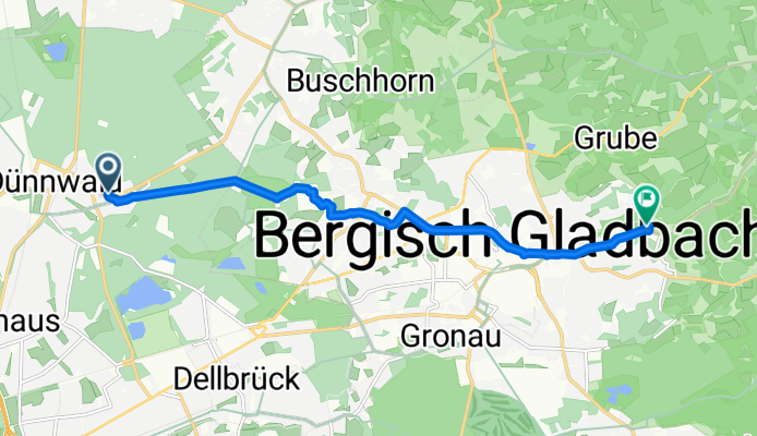
Route template
Mülheim to Bergisch Gladbach

- 53 min
- Duration
- 14.5 km
- Distance
- 72 m
- Ascent
- 32 m
- Descent
- 16.3 km/h
- Avg. speed
- 98 m
- Max. altitude
This ride takes you from Mülheim, a lively district on Cologne’s right bank of the Rhine, out to the charming town of Bergisch Gladbach—perfect for anyone looking to escape the city buzz and enjoy some suburban green. It’s a gentle 14.5 km trek, with just a bit of climbing (about 72 meters ascent), so you’ll break a mild sweat but nothing too crazy.
The route is mostly paved, rolling along quiet roads and relaxed paths—ideal if you like a peaceful ride without too much traffic to worry about. Watch for some sections with paving stones and the occasional stretch of gravel that’ll add a little variety to your journey.
Mülheim brims with history and vibes (don’t miss its cafes or the riverfront!), while Bergisch Gladbach greets you with classic small-town charm and plenty of spots to grab a treat before heading back. This is a great pick for a laid-back half-day adventure that blends both urban and green scenery.
Community
Top users in this region


From our community
The best bike routes from Mülheim to Bergisch Gladbach

Herrenstrunden
Cycling route in Mülheim, North Rhine-Westphalia, Germany
- 12.2 km
- Distance
- 156 m
- Ascent
- 66 m
- Descent

Erlebnisroute Ost
Cycling route in Mülheim, North Rhine-Westphalia, Germany
- 19.7 km
- Distance
- 151 m
- Ascent
- 40 m
- Descent

KVB Köln Thielenbruch
Cycling route in Mülheim, North Rhine-Westphalia, Germany
- 6.2 km
- Distance
- 31 m
- Ascent
- 23 m
- Descent
Alte Dombach Bergisch Gladbach
Cycling route in Mülheim, North Rhine-Westphalia, Germany
- 8.4 km
- Distance
- 100 m
- Ascent
- 47 m
- Descent

Lippeweg 95, Köln nach Oberheidkamper Straße 49 e, Bergisch Gladbach
Cycling route in Mülheim, North Rhine-Westphalia, Germany
- 10 km
- Distance
- 74 m
- Ascent
- 67 m
- Descent

Arbeit1
Cycling route in Mülheim, North Rhine-Westphalia, Germany
- 14.3 km
- Distance
- 181 m
- Ascent
- 51 m
- Descent

Lengthy Dienstag Ride In Köln
Cycling route in Mülheim, North Rhine-Westphalia, Germany
- 5.8 km
- Distance
- 54 m
- Ascent
- 39 m
- Descent

Köningsforst-Spitze
Cycling route in Mülheim, North Rhine-Westphalia, Germany
- 39.5 km
- Distance
- 352 m
- Ascent
- 271 m
- Descent

KFB Sporthalle GL Ahornweg
Cycling route in Mülheim, North Rhine-Westphalia, Germany
- 7.3 km
- Distance
- 50 m
- Ascent
- 23 m
- Descent

Köln Pfad Etappe 1 von 8 - Test
Cycling route in Mülheim, North Rhine-Westphalia, Germany
- 24.2 km
- Distance
- 87 m
- Ascent
- 58 m
- Descent

Köln - Rechtsrheinischer Grüngürtel
Cycling route in Mülheim, North Rhine-Westphalia, Germany
- 55.9 km
- Distance
- 0 m
- Ascent
- 0 m
- Descent

Ackerstraße 144, Köln nach Friedrich-Ebert-Straße 2, Bergisch Gladbach
Cycling route in Mülheim, North Rhine-Westphalia, Germany
- 15.3 km
- Distance
- 211 m
- Ascent
- 38 m
- Descent
Discover more routes
 Lippeweg 95, Köln nach Oberheidkamper Straße 49 e, Bergisch Gladbach
- Distance
- 10 km
- Ascent
- 74 m
- Descent
- 67 m
- Location
- Mülheim, North Rhine-Westphalia, Germany
 Arbeit1
- Distance
- 14.3 km
- Ascent
- 181 m
- Descent
- 51 m
- Location
- Mülheim, North Rhine-Westphalia, Germany
 Lengthy Dienstag Ride In Köln
- Distance
- 5.8 km
- Ascent
- 54 m
- Descent
- 39 m
- Location
- Mülheim, North Rhine-Westphalia, Germany
 Köningsforst-Spitze
- Distance
- 39.5 km
- Ascent
- 352 m
- Descent
- 271 m
- Location
- Mülheim, North Rhine-Westphalia, Germany
 KFB Sporthalle GL Ahornweg
- Distance
- 7.3 km
- Ascent
- 50 m
- Descent
- 23 m
- Location
- Mülheim, North Rhine-Westphalia, Germany
 Köln Pfad Etappe 1 von 8 - Test
- Distance
- 24.2 km
- Ascent
- 87 m
- Descent
- 58 m
- Location
- Mülheim, North Rhine-Westphalia, Germany
 Köln - Rechtsrheinischer Grüngürtel
- Distance
- 55.9 km
- Ascent
- 0 m
- Descent
- 0 m
- Location
- Mülheim, North Rhine-Westphalia, Germany
 Ackerstraße 144, Köln nach Friedrich-Ebert-Straße 2, Bergisch Gladbach
- Distance
- 15.3 km
- Ascent
- 211 m
- Descent
- 38 m
- Location
- Mülheim, North Rhine-Westphalia, Germany
Routes from Mülheim
By bicycle from
Mülheim to Poll
Routes to Bergisch Gladbach
By bicycle from
Deutz to Bergisch Gladbach
By bicycle from
Odenthal to Bergisch Gladbach