
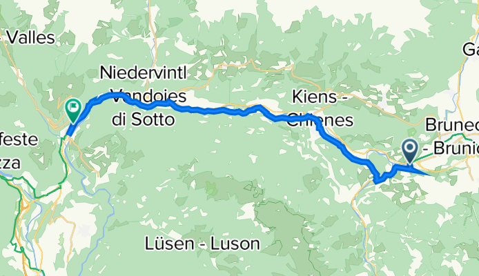
Franz-Hellweger-Platz 10, St. Lorenzen nach Pustertaler Straße 23, Mühlbach
A cycling route starting in St. Lorenzen, Trentino-Alto Adige, Italy.
Overview
About this route
- 1 h 12 min
- Duration
- 23.7 km
- Distance
- 1,803 m
- Ascent
- 1,863 m
- Descent
- 19.6 km/h
- Avg. speed
- ---
- Avg. speed
Route quality
Waytypes & surfaces along the route
Waytypes
Access road
10.9 km
(46 %)
Quiet road
4.2 km
(18 %)
Surfaces
Paved
22.2 km
(94 %)
Unpaved
0.5 km
(2 %)
Asphalt
22.1 km
(93 %)
Gravel
0.5 km
(2 %)
Continue with Bikemap
Use, edit, or download this cycling route
You would like to ride Franz-Hellweger-Platz 10, St. Lorenzen nach Pustertaler Straße 23, Mühlbach or customize it for your own trip? Here is what you can do with this Bikemap route:
Free features
- Save this route as favorite or in collections
- Copy & plan your own version of this route
- Sync your route with Garmin or Wahoo
Premium features
Free trial for 3 days, or one-time payment. More about Bikemap Premium.
- Navigate this route on iOS & Android
- Export a GPX / KML file of this route
- Create your custom printout (try it for free)
- Download this route for offline navigation
Discover more Premium features.
Get Bikemap PremiumFrom our community
Other popular routes starting in St. Lorenzen
 Da Santo Stefano 49 a Santo Stefano 49
- Distance
- 48.5 km
- Ascent
- 907 m
- Descent
- 905 m
- Location
- St. Lorenzen, Trentino-Alto Adige, Italy
 Da San Lorenzo di Sebato, Stazione di San Lorenzo a Via Chienes 4A
- Distance
- 8.1 km
- Ascent
- 93 m
- Descent
- 105 m
- Location
- St. Lorenzen, Trentino-Alto Adige, Italy
 Penny ZAF UPHILL S.LEONARD - CORVARA
- Distance
- 35.8 km
- Ascent
- 861 m
- Descent
- 122 m
- Location
- St. Lorenzen, Trentino-Alto Adige, Italy
 eBiketest Centurion no pogo 2000+
- Distance
- 39.9 km
- Ascent
- 1,092 m
- Descent
- 1,091 m
- Location
- St. Lorenzen, Trentino-Alto Adige, Italy
 Brunico - Anterselva - Passo Stalle
- Distance
- 37.6 km
- Ascent
- 1,266 m
- Descent
- 23 m
- Location
- St. Lorenzen, Trentino-Alto Adige, Italy
 Alpencross 2011 - 3. Etappe
- Distance
- 54.1 km
- Ascent
- 1,997 m
- Descent
- 828 m
- Location
- St. Lorenzen, Trentino-Alto Adige, Italy
 Astjoch Runde
- Distance
- 54.7 km
- Ascent
- 1,400 m
- Descent
- 1,392 m
- Location
- St. Lorenzen, Trentino-Alto Adige, Italy
 mantana, Rio Pusteria, Alpe di Rodengo, Elle, Mantana
- Distance
- 51.1 km
- Ascent
- 1,414 m
- Descent
- 1,412 m
- Location
- St. Lorenzen, Trentino-Alto Adige, Italy
Open it in the app