

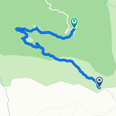
bokor mountain
A cycling route starting in Kampot, Kampot, Cambodia.
Overview
About this route
- 47 min
- Duration
- 17 km
- Distance
- 101 m
- Ascent
- 514 m
- Descent
- 21.6 km/h
- Avg. speed
- ---
- Avg. speed

Continue with Bikemap
Use, edit, or download this cycling route
You would like to ride bokor mountain or customize it for your own trip? Here is what you can do with this Bikemap route:
Free features
- Save this route as favorite or in collections
- Copy & plan your own version of this route
- Sync your route with Garmin or Wahoo
Premium features
Free trial for 3 days, or one-time payment. More about Bikemap Premium.
- Navigate this route on iOS & Android
- Export a GPX / KML file of this route
- Create your custom printout (try it for free)
- Download this route for offline navigation
Discover more Premium features.
Get Bikemap PremiumFrom our community
Other popular routes starting in Kampot
 Day 3 - Bokor Mountain Cycling Map Option 2 - 23.9 Km
- Distance
- 20.4 km
- Ascent
- 472 m
- Descent
- 405 m
- Location
- Kampot, Kampot, Cambodia
 kampot trip
- Distance
- 37.5 km
- Ascent
- 33 m
- Descent
- 35 m
- Location
- Kampot, Kampot, Cambodia
 Dragon Street, Kampot to Kampong Kraeng, Tuek Chhou
- Distance
- 2.6 km
- Ascent
- 44 m
- Descent
- 50 m
- Location
- Kampot, Kampot, Cambodia
 kampot-kep
- Distance
- 21.7 km
- Ascent
- 26 m
- Descent
- 22 m
- Location
- Kampot, Kampot, Cambodia
 kampot Starling ridge
- Distance
- 37.5 km
- Ascent
- 117 m
- Descent
- 76 m
- Location
- Kampot, Kampot, Cambodia
 Bokor Nature Reserve Road, Tuek Chhou to Bokor Nature Reserve Road, Tuek Chhou
- Distance
- 8.1 km
- Ascent
- 493 m
- Descent
- 76 m
- Location
- Kampot, Kampot, Cambodia
 Day 3 - from Kampot to Sangkat Phsar Kandal Ti Muoy
- Distance
- 240 km
- Ascent
- 1,482 m
- Descent
- 1,474 m
- Location
- Kampot, Kampot, Cambodia
 Wokół Kampot
- Distance
- 29.9 km
- Ascent
- 104 m
- Descent
- 65 m
- Location
- Kampot, Kampot, Cambodia
Open it in the app