

R2 A Ossiacher Radweg
A cycling route starting in Wernberg, Carinthia, Austria.
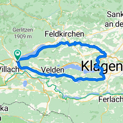
Overview
About this route
Gefahren am: Juni 2021
Verkehrsfrei: ca:12 km; Geringes Verkehrsaufkommen: ca: 2 km; Moderates Verkehrsaufkommen: ca: 00 km, Gefährlich für Kinder nicht geeignet: ca: 00 km
Untergrund: ca: Asphalt ca: 95%; Schotter ca: 5%
Beschreibung: Ab St Magdalen am Südufer des Ossiacher Sees auf eine Radweg unmittelbar neben der L49 bis Alt Ossiach (Kreuzung L49 mit L50) weiter durchs Bleistätter Moos zum R2.
Bewertung: Guter Radweg, leider knapp neben der L49.
Beschilderung: Gut, - bei Kreuzung L49 / L50 etwas unübersichtlich.
GPS Daten stimmen mit der Beschilderung überein: Ja
- -:--
- Duration
- 13.8 km
- Distance
- 156 m
- Ascent
- 158 m
- Descent
- ---
- Avg. speed
- 535 m
- Avg. speed

Route quality
Waytypes & surfaces along the route
Waytypes
Cycleway
11.1 km
(81 %)
Track
1 km
(8 %)
Surfaces
Paved
12.4 km
(90 %)
Unpaved
1 km
(8 %)
Asphalt
12.4 km
(90 %)
Gravel
1 km
(8 %)
Undefined
0.3 km
(2 %)
Continue with Bikemap
Use, edit, or download this cycling route
You would like to ride R2 A Ossiacher Radweg or customize it for your own trip? Here is what you can do with this Bikemap route:
Free features
- Save this route as favorite or in collections
- Copy & plan your own version of this route
- Sync your route with Garmin or Wahoo
Premium features
Free trial for 3 days, or one-time payment. More about Bikemap Premium.
- Navigate this route on iOS & Android
- Export a GPX / KML file of this route
- Create your custom printout (try it for free)
- Download this route for offline navigation
Discover more Premium features.
Get Bikemap PremiumFrom our community
Other popular routes starting in Wernberg
 22. Gerlizen Bergtour
- Distance
- 47.1 km
- Ascent
- 1,574 m
- Descent
- 1,574 m
- Location
- Wernberg, Carinthia, Austria
 Kärntner Seenrunde
- Distance
- 83.3 km
- Ascent
- 909 m
- Descent
- 915 m
- Location
- Wernberg, Carinthia, Austria
 Seenrunde
- Distance
- 56.7 km
- Ascent
- 340 m
- Descent
- 340 m
- Location
- Wernberg, Carinthia, Austria
 🚴♀️E*Bike🇦🇹 Villach-Klagenfurt-Völkermarkt (Alternative)
- Distance
- 71 km
- Ascent
- 325 m
- Descent
- 387 m
- Location
- Wernberg, Carinthia, Austria
 Wörthersee
- Distance
- 66.4 km
- Ascent
- 946 m
- Descent
- 941 m
- Location
- Wernberg, Carinthia, Austria
 MTB-Flach: Ossiachersee/Annenheim - Drauradweg (Rosental)
- Distance
- 31.3 km
- Ascent
- 136 m
- Descent
- 170 m
- Location
- Wernberg, Carinthia, Austria
 Strandbadstraße, Villach nach Ulica Bartolomea Dei Vitrei, Pula
- Distance
- 425.6 km
- Ascent
- 6,252 m
- Descent
- 6,795 m
- Location
- Wernberg, Carinthia, Austria
 KäS1: Villach-Millstatt; 68,6km 510hm
- Distance
- 68.6 km
- Ascent
- 748 m
- Descent
- 631 m
- Location
- Wernberg, Carinthia, Austria
Open it in the app