

Colinele Transilvaniei: Şomartin - Rucăr
A cycling route starting in Bruiu, Judeţul Sibiu, Romania.
Overview
About this route
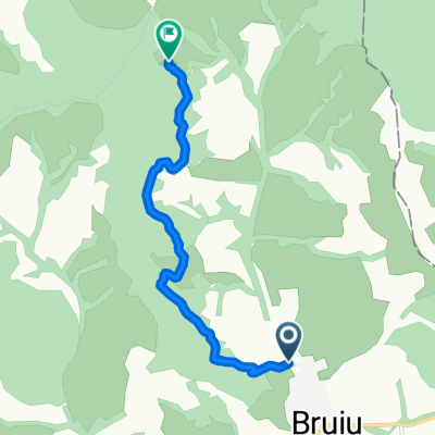
Porneşte spre sud-est, de la biserica evanghelică. Coboară 500 m pe drumul spre Cârţa, apoi mergi spre stânga pe strada ce iese din sat, peste un pod. Continuă pe drumul mai circulat, treci pe lângă o stână şi intră în pădure pe un drum forestier. Ţine acest drum, urmărind marcajele până când traseul intră brusc spre dreapta, urcând în muchie. După ce ajunge în muchie, ţine direcţia sud trecând prin nişte poieni, apoi pe lângă o stână mai mare şi ieşi la drumul care coboară spre satul Feldioara. Aici virează brusc spre stânga, pe un drum mai puţin circulat şi intră în pădure. Traseul continuă prin pădure, iese într-o păşune şi se îndreaptă spre Coasta Popii. Ajungi la o cruce mare din lemn – aici poţi admira râul Olt, Ţara Oltului şi masivul Făgăraş. Din acest punct coboară pe drumul de pământ ce merge în satul Rucăr.
Ai parcurs acest traseu ? Dacă ai identificat probleme de acces (marcaje lipsă, deteriorate sau insuficient de clare, secțiuni impracticabile etc) sau ai sugestii pentru îmbunătățirea lor, te rugăm să ne scrii pe colineletransilvaniei@gmail.com. Nu uita să iei un punct GPS și câteva fotografii - ne va ajuta să intervenim mai repede pentru a remedia situația.
Head south-east, from the evangelical church. Go down 500 m on the road to Cârţa, keep left on the street that goes out of the village, over a bridge. Continue on the most wandered road, pass by a sheepfold and enter the woods on a forest road. Follow the markings until the route suddenly turns right, climbing to the edge. After reaching the top, keep heading south through some clearings, then beside a larger sheepfold and you reach road that descends to Feldioara. Here, suddenly turn left, on a less-circulated road and enter the forest. The route continues through the woods, goes out into a pasture and heads towards hill (Coasta Popii). You reach a large wooden cross - here you can admire the Olt River, the Olt Country and the Fagaras Mountains. From this point, the road descends to the village of Rucăr.
Did you travel this route? If you have identified access problems (missing, damaged or insufficiently clear markings, inaccessible sections etc.) or have suggestions for their improvement, please write to us at transylvanianhighlands@gmail.com. Don't forget to take a GPS point and a few photos - it will help us to intervene faster to fix the situation.
- -:--
- Duration
- 12 km
- Distance
- 1,128 m
- Ascent
- 1,579 m
- Descent
- ---
- Avg. speed
- 668 m
- Avg. speed

Continue with Bikemap
Use, edit, or download this cycling route
You would like to ride Colinele Transilvaniei: Şomartin - Rucăr or customize it for your own trip? Here is what you can do with this Bikemap route:
Free features
- Save this route as favorite or in collections
- Copy & plan your own version of this route
- Sync your route with Garmin or Wahoo
Premium features
Free trial for 3 days, or one-time payment. More about Bikemap Premium.
- Navigate this route on iOS & Android
- Export a GPX / KML file of this route
- Create your custom printout (try it for free)
- Download this route for offline navigation
Discover more Premium features.
Get Bikemap PremiumFrom our community
Other popular routes starting in Bruiu
 Somartin-Bruiu-Gherdeal-Rucãr-Feldioara
- Distance
- 22.5 km
- Ascent
- 387 m
- Descent
- 436 m
- Location
- Bruiu, Judeţul Sibiu, Romania
 ziua 1.2 Coline
- Distance
- 30.5 km
- Ascent
- 613 m
- Descent
- 563 m
- Location
- Bruiu, Judeţul Sibiu, Romania
 Chirpar-Cincu-Chirpar
- Distance
- 59.8 km
- Ascent
- 817 m
- Descent
- 797 m
- Location
- Bruiu, Judeţul Sibiu, Romania
 Restful route in
- Distance
- 5.7 km
- Ascent
- 142 m
- Descent
- 143 m
- Location
- Bruiu, Judeţul Sibiu, Romania
 Colinele Transilvaniei: Şomartin - Rucăr
- Distance
- 12 km
- Ascent
- 1,128 m
- Descent
- 1,579 m
- Location
- Bruiu, Judeţul Sibiu, Romania
 Somartin - Bruiu - Gherdeal
- Distance
- 8.4 km
- Ascent
- 0 m
- Descent
- 0 m
- Location
- Bruiu, Judeţul Sibiu, Romania
 Pe langa Bruiu
- Distance
- 6.3 km
- Ascent
- 198 m
- Descent
- 135 m
- Location
- Bruiu, Judeţul Sibiu, Romania
 6-cincu-fagaras
- Distance
- 118.2 km
- Ascent
- 464 m
- Descent
- 510 m
- Location
- Bruiu, Judeţul Sibiu, Romania
Open it in the app