
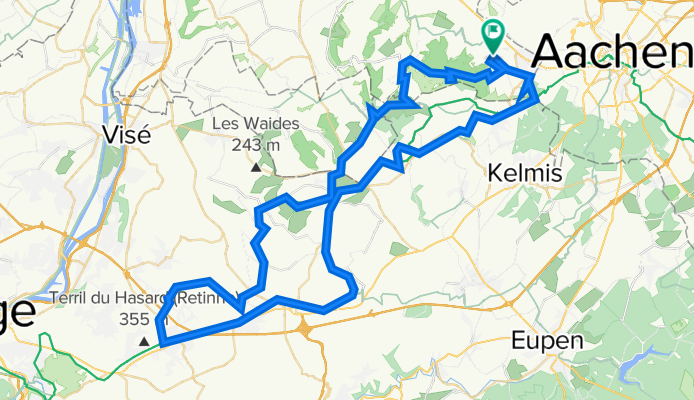
Holset, Ligne 39, Plombieres, Hombourg, Aubel, Micheroux, Charneux, Val Dieu, Camerig, Holset
A cycling route starting in Aachen, North Rhine-Westphalia, Germany.
Overview
About this route
Very nice route over Ligne39 and back over the hills.
22km: Chez Chelie, Rue Hostert, 4880 Aubel, Belgium
28,5km Le fourquet Centre 50, 4890 Thimister-Clermont, Belgium
39km: gare du Micheroux, The Huggy's, hamburgertent
56,5 Abdij de Val Dieu
59.5 Taverne Aubeloise, cafe
68,5km bistro le soigneur Rue de Beusdael 57a, 4851 Plombières, Belgium
- -:--
- Duration
- 82.4 km
- Distance
- 1,208 m
- Ascent
- 1,204 m
- Descent
- ---
- Avg. speed
- 332 m
- Avg. speed
Route quality
Waytypes & surfaces along the route
Waytypes
Path
25.9 km
(31 %)
Quiet road
20.9 km
(25 %)
Surfaces
Paved
67.8 km
(82 %)
Asphalt
67.3 km
(82 %)
Paving stones
0.4 km
(<1 %)
Route highlights
Points of interest along the route
Point of interest after 22.4 km
Chez Chelie, rustpunt
Point of interest after 23.8 km
l'atelier 42 restaurant
Point of interest after 28.2 km
Le Fourquet
Point of interest after 31.1 km
Fort de Battice
Point of interest after 39.8 km
The Huggy's, hamburger
Point of interest after 56.5 km
Abdij Val Dieu
Point of interest after 61.5 km
Taverne Aubeloise, cafe
Point of interest after 70.2 km
bistro le soigneur
Continue with Bikemap
Use, edit, or download this cycling route
You would like to ride Holset, Ligne 39, Plombieres, Hombourg, Aubel, Micheroux, Charneux, Val Dieu, Camerig, Holset or customize it for your own trip? Here is what you can do with this Bikemap route:
Free features
- Save this route as favorite or in collections
- Copy & plan your own version of this route
- Sync your route with Garmin or Wahoo
Premium features
Free trial for 3 days, or one-time payment. More about Bikemap Premium.
- Navigate this route on iOS & Android
- Export a GPX / KML file of this route
- Create your custom printout (try it for free)
- Download this route for offline navigation
Discover more Premium features.
Get Bikemap PremiumFrom our community
Other popular routes starting in Aachen
 aachen-zittau
- Distance
- 1,039.3 km
- Ascent
- 7,225 m
- Descent
- 7,135 m
- Location
- Aachen, North Rhine-Westphalia, Germany
 Aachen-Maastricht-Aachen
- Distance
- 89.7 km
- Ascent
- 702 m
- Descent
- 702 m
- Location
- Aachen, North Rhine-Westphalia, Germany
 TJs extreme :)
- Distance
- 50.6 km
- Ascent
- 615 m
- Descent
- 612 m
- Location
- Aachen, North Rhine-Westphalia, Germany
 nice MTB route
- Distance
- 21.7 km
- Ascent
- 442 m
- Descent
- 450 m
- Location
- Aachen, North Rhine-Westphalia, Germany
 Köpfchen-Lichtenbusch-Vennbahn
- Distance
- 26.9 km
- Ascent
- 193 m
- Descent
- 174 m
- Location
- Aachen, North Rhine-Westphalia, Germany
 Durch den Aachener Stadtwald
- Distance
- 26.7 km
- Ascent
- 320 m
- Descent
- 320 m
- Location
- Aachen, North Rhine-Westphalia, Germany
 12-01-17 Kleine Mergellandrunde 47km-629hm
- Distance
- 47.5 km
- Ascent
- 473 m
- Descent
- 473 m
- Location
- Aachen, North Rhine-Westphalia, Germany
 Trainingsrunde 3(5) 2010
- Distance
- 53 km
- Ascent
- 378 m
- Descent
- 372 m
- Location
- Aachen, North Rhine-Westphalia, Germany
Open it in the app