

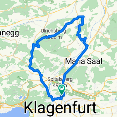
R7 A Görtschitztal Radweg
A cycling route starting in Klagenfurt, Carinthia, Austria.
Overview
About this route
Gefahren: 2020 und 2021 (bis Mösel)
Verkehrsfrei: ca:29 km; Geringes Verkehrsaufkommen: ca: 19 km; Moderates Verkehrsaufkommen: ca: 00 km, Gefährlich für Kinder nicht geeignet: ca: 16 km
Klagenfurt bis Mösel ist ca 48 Kilometer. Ab Mösel bis zur Landesgrenze für Kinder nicht geeignet!
Untergrund: ca: Asphalt ca: 99%; Schotter ca: 01% (Pischeldorf)
Beschreibung: Von Klagenfurt im ZIckZack durch die Stadt und über Gottesbichl zur B 92. Der B 92, auf kommunalen Wegen und auf angelegten Radwegen bis Mösel folgend. Weitgehend gut ausgebauter Radweg neben der B 92.
Bewertung: Guter Radweg in Sinne der Verkehrssicherheit, leider mit wenig Erholungswert in ruhiger Natur. Ab Mösel bis zur Landesgrenze bleibt nur die stark befahrene B 92.
Beschilderung: Ja
GPS Daten stimmen mit der Beschilderung überein: Ja
- -:--
- Duration
- 63.5 km
- Distance
- 926 m
- Ascent
- 439 m
- Descent
- ---
- Avg. speed
- 944 m
- Avg. speed

Route quality
Waytypes & surfaces along the route
Waytypes
Cycleway
24.5 km
(39 %)
Busy road
20.2 km
(32 %)
Surfaces
Paved
40.3 km
(63 %)
Unpaved
1.8 km
(3 %)
Asphalt
39.7 km
(63 %)
Gravel
1.8 km
(3 %)
Continue with Bikemap
Use, edit, or download this cycling route
You would like to ride R7 A Görtschitztal Radweg or customize it for your own trip? Here is what you can do with this Bikemap route:
Free features
- Save this route as favorite or in collections
- Copy & plan your own version of this route
- Sync your route with Garmin or Wahoo
Premium features
Free trial for 3 days, or one-time payment. More about Bikemap Premium.
- Navigate this route on iOS & Android
- Export a GPX / KML file of this route
- Create your custom printout (try it for free)
- Download this route for offline navigation
Discover more Premium features.
Get Bikemap PremiumFrom our community
Other popular routes starting in Klagenfurt
 WörtherseeTrail - Moutianbike
- Distance
- 58.9 km
- Ascent
- 1,279 m
- Descent
- 1,277 m
- Location
- Klagenfurt, Carinthia, Austria
 Ulrichsberg
- Distance
- 37.4 km
- Ascent
- 911 m
- Descent
- 910 m
- Location
- Klagenfurt, Carinthia, Austria
 IRONMAN Austria (2006 - dato)
- Distance
- 89.4 km
- Ascent
- 1,188 m
- Descent
- 1,135 m
- Location
- Klagenfurt, Carinthia, Austria
 Wilsonstraße 71, Klagenfurt am Wörthersee do Wilsonstraße 71, Klagenfurt am Wörthersee
- Distance
- 40.7 km
- Ascent
- 559 m
- Descent
- 561 m
- Location
- Klagenfurt, Carinthia, Austria
 Karwankentour
- Distance
- 150.1 km
- Ascent
- 1,890 m
- Descent
- 1,896 m
- Location
- Klagenfurt, Carinthia, Austria
 Hörzendorf Runde
- Distance
- 34.8 km
- Ascent
- 536 m
- Descent
- 542 m
- Location
- Klagenfurt, Carinthia, Austria
 Klagenfurt Nord- Dürnstein
- Distance
- 34 km
- Ascent
- 234 m
- Descent
- 92 m
- Location
- Klagenfurt, Carinthia, Austria
 9 Seenrunde Klagenfurt-Klagenfurt
- Distance
- 62.8 km
- Ascent
- 754 m
- Descent
- 753 m
- Location
- Klagenfurt, Carinthia, Austria
Open it in the app