

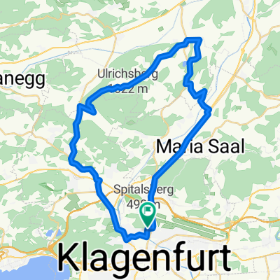
R7 G Loibl Radweg
A cycling route starting in Klagenfurt, Carinthia, Austria.
Overview
About this route
Gefahren: September 2021
Verkehrsfrei: ca:10 km; Geringes Verkehrsaufkommen: ca: 2 km; Moderates Verkehrsaufkommen: ca: 4 km, Gefährlich für Kinder nicht geeignet: ca: 00 km
Untergrund: ca: Asphalt ca: 50%; Schotter ca: 50%
Beschreibung: Ab Klagenfurt, Glanfurtbrücke am Radweg entlang der B 91. Die nächsten Kilometer bis Maria Rain folgen der Begleitstraße der B91 mit teilweisen starken Verkehr. Ab Maria Rain sehr schönes fahren, überwiegend Schotter, über Ferlach - Unterloibl bis zum Eingang der Tscheppaschlucht.
Bewertung: Ab Maria Rain schöner Radweg! Bis Maria Rain moderates bis hohes Verkehrsaufkommen.
Achtung: Nach Unterloibl auf der linken Bachseite bleiben! GPS Daten führen rechts des Baches, jedoch ist der Untergrund schwer zu fahren und der Bach ohne Brücke zu überqueren.
Beschilderung: Ja. - Von Ferlach bis zur Tscheppaschlucht nur ein Hinweis bei Unterloibl
GPS Daten stimmen mit der Beschilderung überein: Ja
- -:--
- Duration
- 15.4 km
- Distance
- 307 m
- Ascent
- 160 m
- Descent
- ---
- Avg. speed
- 588 m
- Avg. speed

Route quality
Waytypes & surfaces along the route
Waytypes
Quiet road
7.4 km
(48 %)
Track
3.1 km
(20 %)
Surfaces
Paved
8.3 km
(54 %)
Unpaved
5.8 km
(37 %)
Asphalt
8.3 km
(54 %)
Gravel
3.1 km
(20 %)
Continue with Bikemap
Use, edit, or download this cycling route
You would like to ride R7 G Loibl Radweg or customize it for your own trip? Here is what you can do with this Bikemap route:
Free features
- Save this route as favorite or in collections
- Copy & plan your own version of this route
- Sync your route with Garmin or Wahoo
Premium features
Free trial for 3 days, or one-time payment. More about Bikemap Premium.
- Navigate this route on iOS & Android
- Export a GPX / KML file of this route
- Create your custom printout (try it for free)
- Download this route for offline navigation
Discover more Premium features.
Get Bikemap PremiumFrom our community
Other popular routes starting in Klagenfurt
 Unterkärnten extreme
- Distance
- 127.9 km
- Ascent
- 2,804 m
- Descent
- 2,780 m
- Location
- Klagenfurt, Carinthia, Austria
 9 Seenrunde Klagenfurt-Klagenfurt
- Distance
- 62.8 km
- Ascent
- 754 m
- Descent
- 753 m
- Location
- Klagenfurt, Carinthia, Austria
 IRONMAN Austria (2006 - dato)
- Distance
- 89.4 km
- Ascent
- 1,188 m
- Descent
- 1,135 m
- Location
- Klagenfurt, Carinthia, Austria
 Hörzendorf Runde
- Distance
- 34.8 km
- Ascent
- 536 m
- Descent
- 542 m
- Location
- Klagenfurt, Carinthia, Austria
 WörtherseeTrail - Moutianbike
- Distance
- 58.9 km
- Ascent
- 1,279 m
- Descent
- 1,277 m
- Location
- Klagenfurt, Carinthia, Austria
 Maria Saaler Berg - Magdalensberg - Retour
- Distance
- 37.6 km
- Ascent
- 764 m
- Descent
- 766 m
- Location
- Klagenfurt, Carinthia, Austria
 Ostersonntag
- Distance
- 75.2 km
- Ascent
- 388 m
- Descent
- 389 m
- Location
- Klagenfurt, Carinthia, Austria
 Klagenfurt I
- Distance
- 29.4 km
- Ascent
- 65 m
- Descent
- 61 m
- Location
- Klagenfurt, Carinthia, Austria
Open it in the app