

North Little Miami Trail
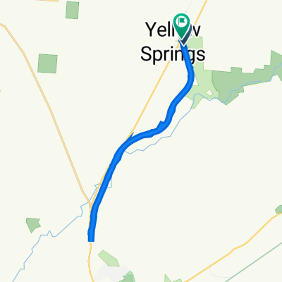
A cycling route starting in Yellow Springs, Ohio, United States of America.
Overview
About this route
North side - Yellow Springs to Xenia. Wanders along US68. Parks at both ends.
Did this June 13. Route south is slight decline and route north is slight incline. Total miles is 15 round trip.
- -:--
- Duration
- 27.1 km
- Distance
- 123 m
- Ascent
- 117 m
- Descent
- ---
- Avg. speed
- ---
- Avg. speed
Route quality
Waytypes & surfaces along the route
Waytypes
Cycleway
16.1 km
(59 %)
Road
5.7 km
(21 %)
Surfaces
Paved
3.2 km
(12 %)
Asphalt
2.9 km
(11 %)
Concrete
0.3 km
(1 %)
Undefined
23.9 km
(88 %)
Continue with Bikemap
Use, edit, or download this cycling route
You would like to ride North Little Miami Trail or customize it for your own trip? Here is what you can do with this Bikemap route:
Free features
- Save this route as favorite or in collections
- Copy & plan your own version of this route
- Sync your route with Garmin or Wahoo
Premium features
Free trial for 3 days, or one-time payment. More about Bikemap Premium.
- Navigate this route on iOS & Android
- Export a GPX / KML file of this route
- Create your custom printout (try it for free)
- Download this route for offline navigation
Discover more Premium features.
Get Bikemap PremiumFrom our community
Other popular routes starting in Yellow Springs
 Yellow Springs--Xenia
- Distance
- 17.1 km
- Ascent
- 56 m
- Descent
- 72 m
- Location
- Yellow Springs, Ohio, United States of America
 102 Dayton St, Yellow Springs to 4650 Creek Rd, Blue Ash
- Distance
- 94.8 km
- Ascent
- 435 m
- Descent
- 478 m
- Location
- Yellow Springs, Ohio, United States of America
 301–333 Corry St, Yellow Springs to 107 Xenia Ave, Yellow Springs
- Distance
- 22.6 km
- Ascent
- 91 m
- Descent
- 93 m
- Location
- Yellow Springs, Ohio, United States of America
 301–333 Corry St, Yellow Springs to 107 Xenia Ave, Yellow Springs
- Distance
- 22.6 km
- Ascent
- 91 m
- Descent
- 93 m
- Location
- Yellow Springs, Ohio, United States of America
 North Little Miami Trail
- Distance
- 27.1 km
- Ascent
- 123 m
- Descent
- 117 m
- Location
- Yellow Springs, Ohio, United States of America
 Young's ice cream charity ride 2021
- Distance
- 155.5 km
- Ascent
- 388 m
- Descent
- 389 m
- Location
- Yellow Springs, Ohio, United States of America
 Dayton/Yellow Springs
- Distance
- 36.3 km
- Ascent
- 83 m
- Descent
- 126 m
- Location
- Yellow Springs, Ohio, United States of America
 Yellow Springs Covered Bridge Ride
- Distance
- 20.3 km
- Ascent
- 159 m
- Descent
- 159 m
- Location
- Yellow Springs, Ohio, United States of America
Open it in the app