

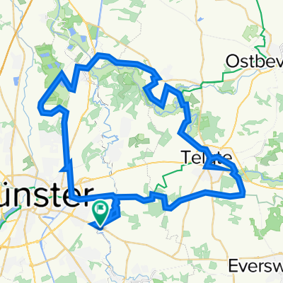
Münster Kleeblatt-Tour
A cycling route starting in Münster, North Rhine-Westphalia, Germany.
Overview
About this route
22.11.2008 / 03.01.2009
Auf Nebenstraßen, Wirtschaftswegen u. Pättkes 139 km in 4 Etappen à 32 - 37 km rund um sowie kreuz u. quer durch Münster. Alle Etappen beliebig kombinierbar.
Etappe 1 – 31,5 km
Domplatz, Servatiiplatz, Promenade, Kreuzviertel, Wienburgpark, Bhf Zentrum Nord, südl. Rieselfelder, Gelmer, Haskenau, Eggert, Südmühle, Handorf, Pleistermühle, Stapelskotten, Mauritz, Ostviertel, Servatiiplatz (Promenade)
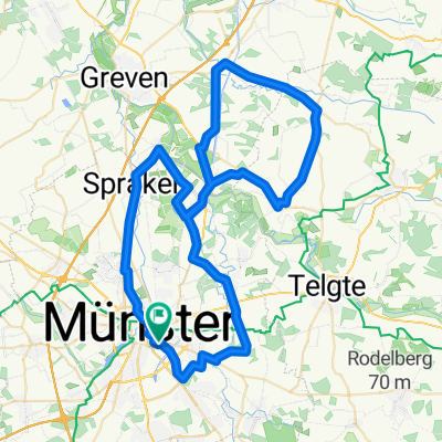
Etappe 2 – 37,5 km
Servatiiplatz (Promenade), Hbf, Stadthafen, Haus Lütkenbeck, Eggert, Wolbeck, Angelmodde, Gremmendorf-Süd, Hiltrup-Ost, Hiltruper See, Amelsbüren, Loevelingloh, Vennheide, Geistviertel, Ludgeriplatz (Promenade)
Etappe 3 – 34,7 km
Ludgeriplatz (Promenade), Aasee, Mecklenbeck-Süd, Albachten-Ost, Oberort, Roxel-West, Burg Hülshoff, Haus Rüschhaus, Haus Sprakel, Gievenbeck-Ost, Schloßgraben, Schloßplatz
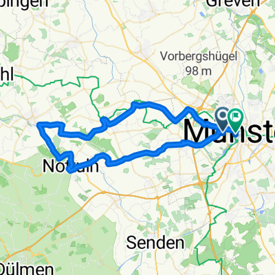
Etappe 4 – 35,4 km
Schloßplatz, Gasselstiege, Häger, Sprakelheide, Aldrup, Gimbte, westl. Rieselfelder, Aatal, Kinderhaus-Ost, Kreuzviertel, Kuhviertel, Überwasser, Domplatz
- -:--
- Duration
- 138.3 km
- Distance
- 311 m
- Ascent
- 313 m
- Descent
- ---
- Avg. speed
- 79 m
- Avg. speed
Route quality
Waytypes & surfaces along the route
Waytypes
Quiet road
61.9 km
(45 %)
Path
40.9 km
(30 %)
Surfaces
Paved
105 km
(76 %)
Unpaved
26.7 km
(19 %)
Asphalt
89.2 km
(65 %)
Gravel
17.9 km
(13 %)
Route highlights
Points of interest along the route
Point of interest after 5.7 km
Etappe 1
Point of interest after 31.3 km
Start Etappe 2
Point of interest after 51.7 km
Etappe 2
Point of interest after 68.9 km
Start Etappe 3
Point of interest after 98.4 km
Etappe 3
Point of interest after 104.3 km
Start Etappe 4
Point of interest after 115.9 km
Etappe 4
Continue with Bikemap
Use, edit, or download this cycling route
You would like to ride Münster Kleeblatt-Tour or customize it for your own trip? Here is what you can do with this Bikemap route:
Free features
- Save this route as favorite or in collections
- Copy & plan your own version of this route
- Sync your route with Garmin or Wahoo
Premium features
Free trial for 3 days, or one-time payment. More about Bikemap Premium.
- Navigate this route on iOS & Android
- Export a GPX / KML file of this route
- Create your custom printout (try it for free)
- Download this route for offline navigation
Discover more Premium features.
Get Bikemap PremiumFrom our community
Other popular routes starting in Münster
 Münster - Telgte - Münster
- Distance
- 39.6 km
- Ascent
- 43 m
- Descent
- 44 m
- Location
- Münster, North Rhine-Westphalia, Germany
 Campingplatz - Emsauen- u. Kanal-Tour
- Distance
- 53.2 km
- Ascent
- 182 m
- Descent
- 179 m
- Location
- Münster, North Rhine-Westphalia, Germany
 Hohe Ward Rundweg
- Distance
- 36.9 km
- Ascent
- 49 m
- Descent
- 48 m
- Location
- Münster, North Rhine-Westphalia, Germany
 Kurze Münsterlandrunde
- Distance
- 38.7 km
- Ascent
- 109 m
- Descent
- 109 m
- Location
- Münster, North Rhine-Westphalia, Germany
 MS-Rieselfelder-Telgte-MS
- Distance
- 52 km
- Ascent
- 99 m
- Descent
- 99 m
- Location
- Münster, North Rhine-Westphalia, Germany
 Erste Münsterland Giro.2011 Erkundungstour
- Distance
- 66.9 km
- Ascent
- 54 m
- Descent
- 54 m
- Location
- Münster, North Rhine-Westphalia, Germany
 Samstagnachmittagsrunde: 117 km Teuto/Schafberg
- Distance
- 117.5 km
- Ascent
- 635 m
- Descent
- 651 m
- Location
- Münster, North Rhine-Westphalia, Germany
 Giro 2010 55km
- Distance
- 56 km
- Ascent
- 238 m
- Descent
- 242 m
- Location
- Münster, North Rhine-Westphalia, Germany
Open it in the app