
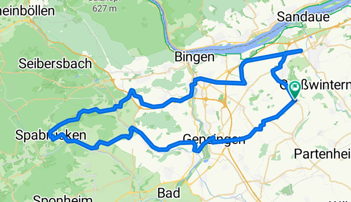
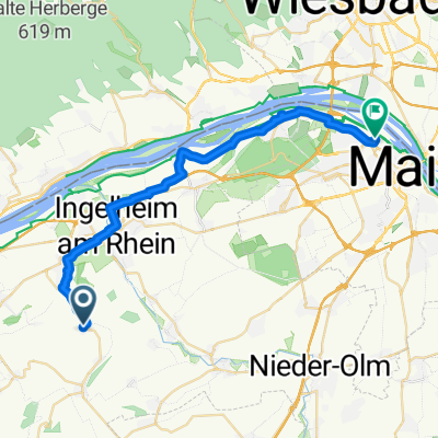
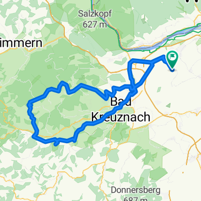
048c: Ingelheim - Gensingen - Dalberg - Schöneberg - Trollbachtal - Ingelheim
A cycling route starting in Appenheim, Rhineland-Palatinate, Germany.
Overview
About this route
Start- & Zielort: Tor 1
Ingelheim - Gau-Algesheim - Appenheim - Aspisheim - Horrweiler - Gensingen - Langenlonsheim - Guldental - Windesheim - Wallhausen - Dalberg - Spabrücken - Schöneberg - Schweppenhausen - Genheim - Waldlaubersheim - Burg-Layen - Münster-Sarmsheim - Büdesheim - Ockenheim - Ingelheim
.
- -:--
- Duration
- 70.6 km
- Distance
- 630 m
- Ascent
- 630 m
- Descent
- ---
- Avg. speed
- ---
- Avg. speed
Route quality
Waytypes & surfaces along the route
Waytypes
Road
30 km
(42 %)
Busy road
27.3 km
(39 %)
Surfaces
Paved
53.6 km
(76 %)
Unpaved
0.7 km
(1 %)
Asphalt
52.4 km
(74 %)
Paving stones
0.8 km
(1 %)
Continue with Bikemap
Use, edit, or download this cycling route
You would like to ride 048c: Ingelheim - Gensingen - Dalberg - Schöneberg - Trollbachtal - Ingelheim or customize it for your own trip? Here is what you can do with this Bikemap route:
Free features
- Save this route as favorite or in collections
- Copy & plan your own version of this route
- Sync your route with Garmin or Wahoo
Premium features
Free trial for 3 days, or one-time payment. More about Bikemap Premium.
- Navigate this route on iOS & Android
- Export a GPX / KML file of this route
- Create your custom printout (try it for free)
- Download this route for offline navigation
Discover more Premium features.
Get Bikemap PremiumFrom our community
Other popular routes starting in Appenheim
 048b: Ingelheim - Gensingen - Argenschwang - Schöneberg - Trollbachtal - Ingelheim
- Distance
- 74.1 km
- Ascent
- 638 m
- Descent
- 638 m
- Location
- Appenheim, Rhineland-Palatinate, Germany
 3 Täler Tour
- Distance
- 131.8 km
- Ascent
- 674 m
- Descent
- 675 m
- Location
- Appenheim, Rhineland-Palatinate, Germany
 048j: Ingelheim - Gensingen - Windesheim - Trollbachtal - Ingelheim
- Distance
- 54.6 km
- Ascent
- 402 m
- Descent
- 402 m
- Location
- Appenheim, Rhineland-Palatinate, Germany
 048c: Ingelheim - Gensingen - Dalberg - Schöneberg - Trollbachtal - Ingelheim
- Distance
- 70.6 km
- Ascent
- 630 m
- Descent
- 630 m
- Location
- Appenheim, Rhineland-Palatinate, Germany
 Rund um den Laurenziberg
- Distance
- 21.7 km
- Ascent
- 150 m
- Descent
- 191 m
- Location
- Appenheim, Rhineland-Palatinate, Germany
 uff die Arbeit
- Distance
- 26.6 km
- Ascent
- 9 m
- Descent
- 107 m
- Location
- Appenheim, Rhineland-Palatinate, Germany
 Flonheimrunde
- Distance
- 51.8 km
- Ascent
- 344 m
- Descent
- 342 m
- Location
- Appenheim, Rhineland-Palatinate, Germany
 Schinderhannes Tour
- Distance
- 117.6 km
- Ascent
- 633 m
- Descent
- 635 m
- Location
- Appenheim, Rhineland-Palatinate, Germany
Open it in the app