

大肚山名坡─中台路
A cycling route starting in Taichung, Taiwan, Taiwan.
Overview
About this route
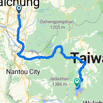
從建功路的嶺東科技大學為起點,沿著中台路向上到台中監理所終點。中途經過神召神學院。
- -:--
- Duration
- 4.4 km
- Distance
- 237 m
- Ascent
- 14 m
- Descent
- ---
- Avg. speed
- ---
- Avg. speed
Route quality
Waytypes & surfaces along the route
Waytypes
Quiet road
2.5 km
(56 %)
Road
2 km
(44 %)
Surfaces
Paved
0.4 km
(9 %)
Asphalt
0.4 km
(9 %)
Undefined
4 km
(91 %)
Continue with Bikemap
Use, edit, or download this cycling route
You would like to ride 大肚山名坡─中台路 or customize it for your own trip? Here is what you can do with this Bikemap route:
Free features
- Save this route as favorite or in collections
- Copy & plan your own version of this route
- Sync your route with Garmin or Wahoo
Premium features
Free trial for 3 days, or one-time payment. More about Bikemap Premium.
- Navigate this route on iOS & Android
- Export a GPX / KML file of this route
- Create your custom printout (try it for free)
- Download this route for offline navigation
Discover more Premium features.
Get Bikemap PremiumFrom our community
Other popular routes starting in Taichung
 台中-日月潭
- Distance
- 72.4 km
- Ascent
- 1,089 m
- Descent
- 559 m
- Location
- Taichung, Taiwan, Taiwan
 136
136- Distance
- 19.3 km
- Ascent
- 754 m
- Descent
- 297 m
- Location
- Taichung, Taiwan, Taiwan
 一日一望高 可以遠離醫生
- Distance
- 36 km
- Ascent
- 334 m
- Descent
- 311 m
- Location
- Taichung, Taiwan, Taiwan
 傳說中的136
- Distance
- 19.2 km
- Ascent
- 997 m
- Descent
- 961 m
- Location
- Taichung, Taiwan, Taiwan
 環島路線-海線
- Distance
- 1,073 km
- Ascent
- 1,095 m
- Descent
- 1,095 m
- Location
- Taichung, Taiwan, Taiwan
 日月潭 平易近人 路線
- Distance
- 149.1 km
- Ascent
- 1,064 m
- Descent
- 1,062 m
- Location
- Taichung, Taiwan, Taiwan
 牛角坑大石壁
- Distance
- 12 km
- Ascent
- 465 m
- Descent
- 463 m
- Location
- Taichung, Taiwan, Taiwan
 台中-日月潭
- Distance
- 157.8 km
- Ascent
- 1,048 m
- Descent
- 1,048 m
- Location
- Taichung, Taiwan, Taiwan
Open it in the app