
Turmberg Funkturm Bismarckturm
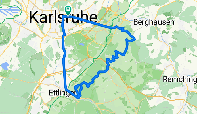
A cycling route starting in Karlsruhe, Baden-Württemberg, Germany.
Overview
About this route
Sehr schöne und kleine Mountainbike Route mit allen Türmen auf einen Schlag: Turmberg, Funkturm und Bismarckturm.
Beginnend mit einer Warmfahrsprintstrecke vom Kronenplatz nach Durlach. Von dortaus sehr steil zum Turmberg.
Dann schöne kleinen Trails mit kurzen Anstiegen und ach Stichen zum Funkturm.
Hier geht es quer durchs Gelände bis zum Bismarckturm.
Mit der verdienten Abschlussabfahrt nach Ettlingen rein.
Von hieraus kann man nochmal einen richtigen Sprint bis zur City nach Karlsruhe einlegen.
- -:--
- Duration
- 33.8 km
- Distance
- 473 m
- Ascent
- 473 m
- Descent
- ---
- Avg. speed
- ---
- Avg. speed
Route highlights
Points of interest along the route

Photo after 7.2 km
Turmberg

Photo after 17.8 km
Funkturm

Photo after 23.9 km
Bismarckturm
Continue with Bikemap
Use, edit, or download this cycling route
You would like to ride Turmberg Funkturm Bismarckturm or customize it for your own trip? Here is what you can do with this Bikemap route:
Free features
- Save this route as favorite or in collections
- Copy & plan your own version of this route
- Sync your route with Garmin or Wahoo
Premium features
Free trial for 3 days, or one-time payment. More about Bikemap Premium.
- Navigate this route on iOS & Android
- Export a GPX / KML file of this route
- Create your custom printout (try it for free)
- Download this route for offline navigation
Discover more Premium features.
Get Bikemap PremiumFrom our community
Other popular routes starting in Karlsruhe
 KA - Durlach - Wattkopf - Muschelbach - Thomashof - KA
- Distance
- 48.9 km
- Ascent
- 656 m
- Descent
- 654 m
- Location
- Karlsruhe, Baden-Württemberg, Germany
 Durlach-Pfinztal Runde
- Distance
- 39.3 km
- Ascent
- 413 m
- Descent
- 406 m
- Location
- Karlsruhe, Baden-Württemberg, Germany
 kleine Rheinhafenrunde (ab/bis Nottingham Anlage, Karlsruhe)
- Distance
- 22.1 km
- Ascent
- 25 m
- Descent
- 30 m
- Location
- Karlsruhe, Baden-Württemberg, Germany
 Kleine Feierabendrunde
- Distance
- 24.3 km
- Ascent
- 99 m
- Descent
- 100 m
- Location
- Karlsruhe, Baden-Württemberg, Germany
 Kreuzung Adenauerring / Grabener Allee zur Insel Rott
- Distance
- 16.5 km
- Ascent
- 17 m
- Descent
- 37 m
- Location
- Karlsruhe, Baden-Württemberg, Germany
 Karlsruhe - Turmberg - Stupferich - Mutschelbach - Langensteinbach - Ittersbach - Schöllbronn - Ettlingen - Karlsruhe
- Distance
- 59 km
- Ascent
- 514 m
- Descent
- 515 m
- Location
- Karlsruhe, Baden-Württemberg, Germany
 durch die Vorderpfalz
- Distance
- 69.7 km
- Ascent
- 141 m
- Descent
- 150 m
- Location
- Karlsruhe, Baden-Württemberg, Germany
 KA: Abendlicher Rundkurs +/- 1h 15min
- Distance
- 30.5 km
- Ascent
- 51 m
- Descent
- 49 m
- Location
- Karlsruhe, Baden-Württemberg, Germany
Open it in the app