
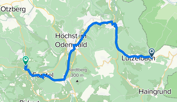
L3259, Lützelbach nach Sonnenberg 11, Höchst im Odenwald
A cycling route starting in Lützelbach, Hesse, Germany.
Overview
About this route
- 1 h 7 min
- Duration
- 18.9 km
- Distance
- 263 m
- Ascent
- 253 m
- Descent
- 17 km/h
- Avg. speed
- 391 m
- Avg. speed

Route quality
Waytypes & surfaces along the route
Waytypes
Quiet road
4.9 km
(26 %)
Busy road
4.8 km
(25 %)
Surfaces
Paved
10.2 km
(54 %)
Unpaved
0.2 km
(<1 %)
Asphalt
8.4 km
(44 %)
Paved (undefined)
1.8 km
(10 %)
Continue with Bikemap
Use, edit, or download this cycling route
You would like to ride L3259, Lützelbach nach Sonnenberg 11, Höchst im Odenwald or customize it for your own trip? Here is what you can do with this Bikemap route:
Free features
- Save this route as favorite or in collections
- Copy & plan your own version of this route
- Sync your route with Garmin or Wahoo
Premium features
Free trial for 3 days, or one-time payment. More about Bikemap Premium.
- Navigate this route on iOS & Android
- Export a GPX / KML file of this route
- Create your custom printout (try it for free)
- Download this route for offline navigation
Discover more Premium features.
Get Bikemap PremiumFrom our community
Other popular routes starting in Lützelbach
 Windlücke von Lützelbach Breitenbrunner Str.
- Distance
- 4 km
- Ascent
- 144 m
- Descent
- 22 m
- Location
- Lützelbach, Hesse, Germany
 Eisenbach Loop
- Distance
- 32 km
- Ascent
- 674 m
- Descent
- 672 m
- Location
- Lützelbach, Hesse, Germany
 Miltenberg-Wenschdorf-<neudorf-Amorbach-Boxbrunn
- Distance
- 104.2 km
- Ascent
- 1,166 m
- Descent
- 1,145 m
- Location
- Lützelbach, Hesse, Germany
 Odenwaldklassiker
- Distance
- 99.4 km
- Ascent
- 1,078 m
- Descent
- 1,078 m
- Location
- Lützelbach, Hesse, Germany
 Vorbei an Odenwalddörfern
- Distance
- 29.3 km
- Ascent
- 770 m
- Descent
- 768 m
- Location
- Lützelbach, Hesse, Germany
 Durch das Breuberger Land
- Distance
- 25.5 km
- Ascent
- 549 m
- Descent
- 549 m
- Location
- Lützelbach, Hesse, Germany
 Lützelbach-Beerfelden
- Distance
- 43.3 km
- Ascent
- 731 m
- Descent
- 606 m
- Location
- Lützelbach, Hesse, Germany
 "Drahtesel" MTB-Tour am 01.02.2020
- Distance
- 33.6 km
- Ascent
- 622 m
- Descent
- 621 m
- Location
- Lützelbach, Hesse, Germany
Open it in the app