

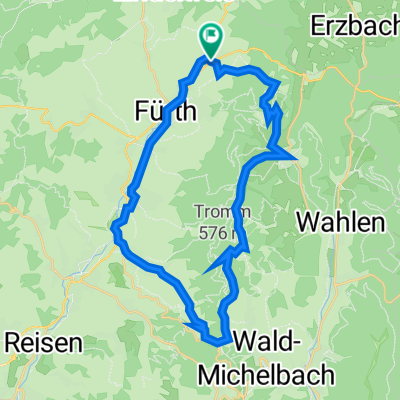
Gassbachtal-Grasellenbach-Hüttental
A cycling route starting in Fürth, Hesse, Germany.
Overview
About this route
- 4 h 43 min
- Duration
- 46.7 km
- Distance
- 797 m
- Ascent
- 796 m
- Descent
- 9.9 km/h
- Avg. speed
- 518 m
- Avg. speed

Route quality
Waytypes & surfaces along the route
Waytypes
Track
18 km
(39 %)
Quiet road
16.5 km
(35 %)
Surfaces
Paved
23.7 km
(51 %)
Unpaved
20 km
(43 %)
Asphalt
17.7 km
(38 %)
Gravel
17 km
(36 %)
Continue with Bikemap
Use, edit, or download this cycling route
You would like to ride Gassbachtal-Grasellenbach-Hüttental or customize it for your own trip? Here is what you can do with this Bikemap route:
Free features
- Save this route as favorite or in collections
- Copy & plan your own version of this route
- Sync your route with Garmin or Wahoo
Premium features
Free trial for 3 days, or one-time payment. More about Bikemap Premium.
- Navigate this route on iOS & Android
- Export a GPX / KML file of this route
- Create your custom printout (try it for free)
- Download this route for offline navigation
Discover more Premium features.
Get Bikemap PremiumFrom our community
Other popular routes starting in Fürth
 Tromm Rude
- Distance
- 29 km
- Ascent
- 579 m
- Descent
- 579 m
- Location
- Fürth, Hesse, Germany
 Fürth-Wechnitz-Tromm Rundweg
- Distance
- 24.9 km
- Ascent
- 638 m
- Descent
- 625 m
- Location
- Fürth, Hesse, Germany
 Führt - Wechnitz - Mossauer Hoehe - Marbach - Hammelbach - Rundweg
- Distance
- 57.2 km
- Ascent
- 751 m
- Descent
- 751 m
- Location
- Fürth, Hesse, Germany
 Rundweg Fürth-Guldenklingerhöhe
- Distance
- 21.8 km
- Ascent
- 401 m
- Descent
- 394 m
- Location
- Fürth, Hesse, Germany
 2019 Tour 05
- Distance
- 12.4 km
- Ascent
- 172 m
- Descent
- 169 m
- Location
- Fürth, Hesse, Germany
 Fürth - Tromm - Siedelsbrunn - Weinheim - Fürth
- Distance
- 52.5 km
- Ascent
- 560 m
- Descent
- 562 m
- Location
- Fürth, Hesse, Germany
 - In den Gärten 5
- Distance
- 24.2 km
- Ascent
- 480 m
- Descent
- 480 m
- Location
- Fürth, Hesse, Germany
 MTB2020,MLS
- Distance
- 29.7 km
- Ascent
- 764 m
- Descent
- 765 m
- Location
- Fürth, Hesse, Germany
Open it in the app