

Grand huit en Genevois
A cycling route starting in Geneva, Canton of Geneva, Switzerland.
Overview
About this route
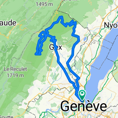
Escapade en huit entre Genève et les Gorges du Fier, à travers les paysages variés du Genevois : coteaux viticoles du Mandement, vallon de l'Allondon, pied du Jura, pont Carnot, Vuache et plateau des Daines, val des Usses, collines et pâturages savoyards, Gorges du Fier, Rhône, bourg de Seyssel, défilé de Fort-l'Écluse.
Routes à faible trafic sur l'ensemble du parcours, à l'exception des Gorges du Fier, qu'il vaut mieux éviter en semaine - mais aucun problème le dimanche. Retour par l'itinéraire officiel ViaRhôna (Eurovélo 17), de Seyssel à Chancy.
Distance : 137 km
Dénivelé positif : 2000 m
Durée : 7h30 (plus pauses)
Altitude maximale : 650 m (Clermont-en-Genevois)
Plus d'informations sur www.europebybike.info
- -:--
- Duration
- 136.9 km
- Distance
- 2,222 m
- Ascent
- 2,221 m
- Descent
- ---
- Avg. speed
- 651 m
- Max. altitude

Route quality
Waytypes & surfaces along the route
Waytypes
Road
51.3 km
(37 %)
Quiet road
45.7 km
(33 %)
Surfaces
Paved
67 km
(49 %)
Unpaved
2.3 km
(2 %)
Asphalt
63.5 km
(46 %)
Paved (undefined)
3.1 km
(2 %)
Route highlights
Points of interest along the route
Drinking water after 13.8 km
Fontaine
Drinking water after 18.5 km
Fontaine
Drinking water after 82.8 km
Eau potable
Continue with Bikemap
Use, edit, or download this cycling route
You would like to ride Grand huit en Genevois or customize it for your own trip? Here is what you can do with this Bikemap route:
Free features
- Save this route as favorite or in collections
- Copy & plan your own version of this route
- Split it into stages to create a multi-day tour
- Sync your route with Garmin or Wahoo
Premium features
Free trial for 3 days, or one-time payment. More about Bikemap Premium.
- Navigate this route on iOS & Android
- Export a GPX / KML file of this route
- Create your custom printout (try it for free)
- Download this route for offline navigation
Discover more Premium features.
Get Bikemap PremiumFrom our community
Other popular routes starting in Geneva
![29.08 [parcours valloné-roulant]](https://media.bikemap.net/routes/4408925/staticmaps/in_ef9e8f71-6a59-4ff9-a5ee-ab6aa312b752_400x400_bikemap-2021-3D-static.png) 29.08 [parcours valloné-roulant]
29.08 [parcours valloné-roulant]- Distance
- 93.7 km
- Ascent
- 439 m
- Descent
- 440 m
- Location
- Geneva, Canton of Geneva, Switzerland
 25.11 WePerf
- Distance
- 72.5 km
- Ascent
- 380 m
- Descent
- 370 m
- Location
- Geneva, Canton of Geneva, Switzerland
 Pas de l'Echine
- Distance
- 84.8 km
- Ascent
- 1,707 m
- Descent
- 1,705 m
- Location
- Geneva, Canton of Geneva, Switzerland
 Bike the Lake - |Lac Leman
- Distance
- 180.7 km
- Ascent
- 271 m
- Descent
- 271 m
- Location
- Geneva, Canton of Geneva, Switzerland
 Vallée Verte Col Hunting
- Distance
- 92.6 km
- Ascent
- 1,629 m
- Descent
- 1,577 m
- Location
- Geneva, Canton of Geneva, Switzerland
 Tour du Bassin genevois (2)
- Distance
- 88.4 km
- Ascent
- 1,700 m
- Descent
- 1,699 m
- Location
- Geneva, Canton of Geneva, Switzerland
 J.6.Genf - Lyon Zentrum
- Distance
- 195.8 km
- Ascent
- 1,023 m
- Descent
- 1,174 m
- Location
- Geneva, Canton of Geneva, Switzerland
 Bords du Rhône (Petit Parcours)
- Distance
- 35.6 km
- Ascent
- 417 m
- Descent
- 417 m
- Location
- Geneva, Canton of Geneva, Switzerland
Open it in the app