

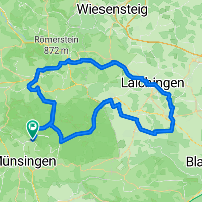
Münsingen-TrupÜbPl-Zainingen-Hengen-Trailfingen-Münsingen
A cycling route starting in Münsingen, Baden-Württemberg, Germany.
Overview
About this route
- -:--
- Duration
- 33.6 km
- Distance
- 464 m
- Ascent
- 464 m
- Descent
- ---
- Avg. speed
- 818 m
- Avg. speed

Route quality
Waytypes & surfaces along the route
Waytypes
Track
13.2 km
(39 %)
Quiet road
12.8 km
(38 %)
Surfaces
Paved
23.6 km
(70 %)
Unpaved
5.3 km
(16 %)
Asphalt
21.6 km
(64 %)
Gravel
2.6 km
(8 %)
Continue with Bikemap
Use, edit, or download this cycling route
You would like to ride Münsingen-TrupÜbPl-Zainingen-Hengen-Trailfingen-Münsingen or customize it for your own trip? Here is what you can do with this Bikemap route:
Free features
- Save this route as favorite or in collections
- Copy & plan your own version of this route
- Sync your route with Garmin or Wahoo
Premium features
Free trial for 3 days, or one-time payment. More about Bikemap Premium.
- Navigate this route on iOS & Android
- Export a GPX / KML file of this route
- Create your custom printout (try it for free)
- Download this route for offline navigation
Discover more Premium features.
Get Bikemap PremiumFrom our community
Other popular routes starting in Münsingen
 50 Samstag 2025
- Distance
- 50 km
- Ascent
- 611 m
- Descent
- 610 m
- Location
- Münsingen, Baden-Württemberg, Germany
 Buchbare Tour 4 | 4. Tag Variante 2
- Distance
- 21.6 km
- Ascent
- 262 m
- Descent
- 260 m
- Location
- Münsingen, Baden-Württemberg, Germany
 Buchbare Tour 4 | 3. Tag
- Distance
- 18.1 km
- Ascent
- 334 m
- Descent
- 333 m
- Location
- Münsingen, Baden-Württemberg, Germany
 Von Münsingen bis Gomadingen
- Distance
- 8.7 km
- Ascent
- 128 m
- Descent
- 256 m
- Location
- Münsingen, Baden-Württemberg, Germany
 Buchbare Tour 4 | 2. Tag
- Distance
- 10.8 km
- Ascent
- 196 m
- Descent
- 195 m
- Location
- Münsingen, Baden-Württemberg, Germany
 Trailfinger Säge-Laichingen
- Distance
- 59.4 km
- Ascent
- 857 m
- Descent
- 856 m
- Location
- Münsingen, Baden-Württemberg, Germany
 Über die Albhöhen ins Lautertal
- Distance
- 38.4 km
- Ascent
- 665 m
- Descent
- 680 m
- Location
- Münsingen, Baden-Württemberg, Germany
 Alb Gold Tour
- Distance
- 67 km
- Ascent
- 627 m
- Descent
- 626 m
- Location
- Münsingen, Baden-Württemberg, Germany
Open it in the app