Premium Badge Download on the App Store Get it on Google Play Turn-by-turn Navigation Offline Maps Bike Type Optimized Routing Premium Maps Custom Bike Computer Export Routes Route Previews Fall Detection Premium Support

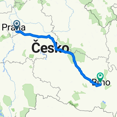
Cycling Route in Hodkovičky, Hlavní město Praha, Czechia

Praha - okolí 05

1
Open this route in the Bikemap app

Open this route in the Bikemap app

Open this route in Bikemap Web

Open this route in Bikemap Web

33 km
Distance
91 m
Ascent
91 m
Descent
-:-- h
Duration
-- km/h
Avg. Speed
--- m
Max. Elevation

About This Route

6.6.2010

KRČ – BARRANDOV – LAHOVICE – RADOTÍN – ČERNOŠICE – LIPENCE – ZBRASLAV – MODŘANY - KRČ

Krč areál Eagles – cyklostezka – Braník – Barrandovský most – podél řeky – asfalt – Chuchle – Lahvičky – Lahvice – pod mostem – podél Berounky – objezd po silnici – zpět na cyklostezku – podél vody – vilkami – zahradní restaurace – Radotín – podél vody – cestička – Černošice – doleva přes most – cyklostezkou – č.3 – polem – Lipence – po silnici – doprava stoupání – Zbraslav – sjezd - město – přes most – Vltava – podél vody – Komořany – Modřany – Braník – cyklostezka – doprava - údolím –stoupání - Krč Eagles hřiště

This cycling route is ideal for: MTB

You will cycle on the following surfaces: Paved Unpaved Gravel

Customize this cycling route with the Bikemap route planner.

Make it yours!

Did you know? You can use this route as a template in our cycling route planner if you don't wish to start from scratch. Customize it based on your needs to plan your perfect cycling tour.

Open it in the app