

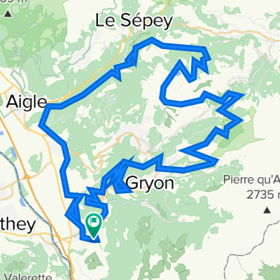
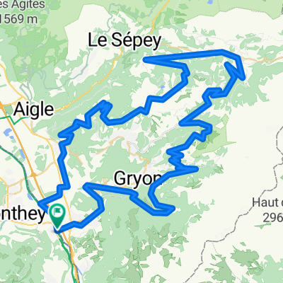
Massongex-Plans sur Bex-Gryon
A cycling route starting in Bex, Canton of Vaud, Switzerland.
Overview
About this route
Courte boucle dans le Chablais vaudois, empruntant partiellement le parcours balisé n° 68 de la Suisse à VTT ("Alpes de la Région du Léman Bike").
Routes goudronnées et chemins forestiers roulants, sans aucune difficulté, en dehors de quelques passages raides, à la montée.
Aux Plans-sur-Bex, cela vaut la peine de continuer jusqu'à Pont-de-Nant, au pied de la belle paroi du Grand Muveran (3051 m). Si la route est déneigée... Notez que les sentiers sont réservés aux piétons.
Magnifiques panoramas sur les Alpes chablaisiennes (Muverans, Diablerets, Miroir d'Argentine, Dents du Midi) et la vallée du Rhône.
A la descente, on peut passer par les fameuses Mines de Sel, si on ne rate pas la bifurcation dans la forêt.
Itinéraire facilement accessible à vélo ou en train : son départ se situe sur la Route du Rhône (Suisse à vélo n°1), à proximité de la gare de Massongex, sur la ligne régionale Martigny-St Gingolph.
Distance : 39 km
Dénivelé positif : 1050 m
Durée : 3h00
Altitude maximale : 1290 m (route de Solalex)
Plus d'informations sur www.europebybike.info
- -:--
- Duration
- 38.7 km
- Distance
- 1,234 m
- Ascent
- 1,234 m
- Descent
- ---
- Avg. speed
- 1,298 m
- Avg. speed

Route quality
Waytypes & surfaces along the route
Waytypes
Quiet road
17.8 km
(46 %)
Track
8 km
(21 %)
Surfaces
Paved
15.7 km
(40 %)
Unpaved
3.2 km
(8 %)
Asphalt
15 km
(39 %)
Gravel
3 km
(8 %)
Route highlights
Points of interest along the route
Point of interest after 11.9 km
Route non déneigée...
Point of interest after 12.7 km
Sentiers piétons
Point of interest after 31.2 km
Bifurcation vers les Mines de Sel
Continue with Bikemap
Use, edit, or download this cycling route
You would like to ride Massongex-Plans sur Bex-Gryon or customize it for your own trip? Here is what you can do with this Bikemap route:
Free features
- Save this route as favorite or in collections
- Copy & plan your own version of this route
- Sync your route with Garmin or Wahoo
Premium features
Free trial for 3 days, or one-time payment. More about Bikemap Premium.
- Navigate this route on iOS & Android
- Export a GPX / KML file of this route
- Create your custom printout (try it for free)
- Download this route for offline navigation
Discover more Premium features.
Get Bikemap PremiumFrom our community
Other popular routes starting in Bex
 AlpenTour2018_E6-8
- Distance
- 140.7 km
- Ascent
- 1,469 m
- Descent
- 1,451 m
- Location
- Bex, Canton of Vaud, Switzerland
 route meer van Geneve 2013
- Distance
- 351.6 km
- Ascent
- 487 m
- Descent
- 476 m
- Location
- Bex, Canton of Vaud, Switzerland
 Facile à conduire Bex
- Distance
- 28.4 km
- Ascent
- 772 m
- Descent
- 724 m
- Location
- Bex, Canton of Vaud, Switzerland
 Gravel Bex autour de Villars
- Distance
- 76.4 km
- Ascent
- 1,960 m
- Descent
- 1,959 m
- Location
- Bex, Canton of Vaud, Switzerland
 Les Giettes par Vérossaz suivi de Champéry par la route des Rives
- Distance
- 45.1 km
- Ascent
- 1,233 m
- Descent
- 1,231 m
- Location
- Bex, Canton of Vaud, Switzerland
 Aigle-Seppey-Forclaz-Leglise-Mosses-Moellé-Leysin-Aigle
- Distance
- 83.1 km
- Ascent
- 1,741 m
- Descent
- 1,741 m
- Location
- Bex, Canton of Vaud, Switzerland
 Col de la Croix different
- Distance
- 86.1 km
- Ascent
- 2,493 m
- Descent
- 2,496 m
- Location
- Bex, Canton of Vaud, Switzerland
 Monthey -> Genève
- Distance
- 133.1 km
- Ascent
- 2,466 m
- Descent
- 2,492 m
- Location
- Bex, Canton of Vaud, Switzerland
Open it in the app