

2021-12-10 東涌,深屈,機場郊遊樂
A cycling route starting in Tung Chung, Islands District, Hong Kong.
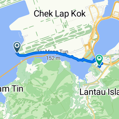
Overview
About this route
- -:--
- Duration
- 74.6 km
- Distance
- 1,720 m
- Ascent
- 1,717 m
- Descent
- ---
- Avg. speed
- 127 m
- Max. altitude

Route photos


Continue with Bikemap
Use, edit, or download this cycling route
You would like to ride 2021-12-10 東涌,深屈,機場郊遊樂 or customize it for your own trip? Here is what you can do with this Bikemap route:
Free features
- Save this route as favorite or in collections
- Copy & plan your own version of this route
- Sync your route with Garmin or Wahoo
Premium features
Free trial for 3 days, or one-time payment. More about Bikemap Premium.
- Navigate this route on iOS & Android
- Export a GPX / KML file of this route
- Create your custom printout (try it for free)
- Download this route for offline navigation
Discover more Premium features.
Get Bikemap PremiumFrom our community
Other popular routes starting in Tung Chung
 2021-12-10 東涌,深屈,機場郊遊樂
- Distance
- 74.6 km
- Ascent
- 1,720 m
- Descent
- 1,717 m
- Location
- Tung Chung, Islands District, Hong Kong
 大嶼山白芒梅窩大佛深屈道
- Distance
- 44.8 km
- Ascent
- 936 m
- Descent
- 943 m
- Location
- Tung Chung, Islands District, Hong Kong
 TAI O (Old TC Road)
- Distance
- 41.3 km
- Ascent
- 1,025 m
- Descent
- 1,025 m
- Location
- Tung Chung, Islands District, Hong Kong
 大澳古道
大澳古道- Distance
- 22.1 km
- Ascent
- 366 m
- Descent
- 357 m
- Location
- Tung Chung, Islands District, Hong Kong
 Airport (Road)
- Distance
- 6.4 km
- Ascent
- 72 m
- Descent
- 71 m
- Location
- Tung Chung, Islands District, Hong Kong
 分流砲台(石璧-大澳)
- Distance
- 17.5 km
- Ascent
- 387 m
- Descent
- 454 m
- Location
- Tung Chung, Islands District, Hong Kong
 1 Mui Wo Rural Committee Road, Mui Wo to 9 Mui Wo Chung Hau Street, Mui Wo
- Distance
- 6.3 km
- Ascent
- 0 m
- Descent
- 3 m
- Location
- Tung Chung, Islands District, Hong Kong
 初試大嶼山
初試大嶼山- Distance
- 11.3 km
- Ascent
- 7 m
- Descent
- 17 m
- Location
- Tung Chung, Islands District, Hong Kong
Open it in the app