
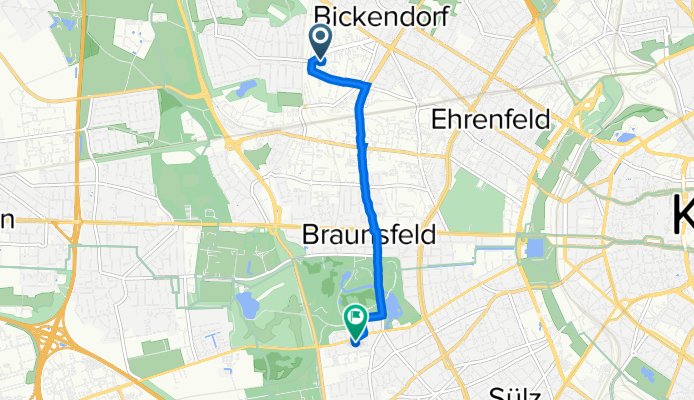
Wilhelm-Mauser-Straße 59, Köln nach Prälat-van-Acken-Straße 5, Köln
A cycling route starting in Mengenich, North Rhine-Westphalia, Germany.
Overview
About this route
- 20 min
- Duration
- 4.4 km
- Distance
- 10 m
- Ascent
- 4 m
- Descent
- 13.5 km/h
- Avg. speed
- 55 m
- Avg. speed
Route quality
Waytypes & surfaces along the route
Waytypes
Road
1.9 km
(43 %)
Path
0.9 km
(20 %)
Surfaces
Paved
3.4 km
(76 %)
Asphalt
2.9 km
(65 %)
Paved (undefined)
0.3 km
(6 %)
Continue with Bikemap
Use, edit, or download this cycling route
You would like to ride Wilhelm-Mauser-Straße 59, Köln nach Prälat-van-Acken-Straße 5, Köln or customize it for your own trip? Here is what you can do with this Bikemap route:
Free features
- Save this route as favorite or in collections
- Copy & plan your own version of this route
- Sync your route with Garmin or Wahoo
Premium features
Free trial for 3 days, or one-time payment. More about Bikemap Premium.
- Navigate this route on iOS & Android
- Export a GPX / KML file of this route
- Create your custom printout (try it for free)
- Download this route for offline navigation
Discover more Premium features.
Get Bikemap PremiumFrom our community
Other popular routes starting in Mengenich
 Pesch bis Zons
- Distance
- 16 km
- Ascent
- 0 m
- Descent
- 10 m
- Location
- Mengenich, North Rhine-Westphalia, Germany
 Ausflug
- Distance
- 53 km
- Ascent
- 166 m
- Descent
- 166 m
- Location
- Mengenich, North Rhine-Westphalia, Germany
 Runde Fühlinger See Worringen
- Distance
- 40 km
- Ascent
- 158 m
- Descent
- 204 m
- Location
- Mengenich, North Rhine-Westphalia, Germany
 Wasserwerk 2
- Distance
- 8.5 km
- Ascent
- 28 m
- Descent
- 28 m
- Location
- Mengenich, North Rhine-Westphalia, Germany
 Schloss Rheydt
- Distance
- 63.4 km
- Ascent
- 145 m
- Descent
- 143 m
- Location
- Mengenich, North Rhine-Westphalia, Germany
 Köln-WahnerHeide-Rheintour
- Distance
- 71.5 km
- Ascent
- 160 m
- Descent
- 160 m
- Location
- Mengenich, North Rhine-Westphalia, Germany
 Bedburg Alt-Kaster
- Distance
- 60.1 km
- Ascent
- 131 m
- Descent
- 130 m
- Location
- Mengenich, North Rhine-Westphalia, Germany
 LF - Auweiler rum
- Distance
- 12.9 km
- Ascent
- 39 m
- Descent
- 39 m
- Location
- Mengenich, North Rhine-Westphalia, Germany
Open it in the app