

Waldidylle im Naturpark Augsburg Westl. Wälder
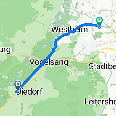
A cycling route starting in Diedorf, Bavaria, Germany.
Overview
About this route
Die mit einem Tannenbaum auf grünem Grund gut gekennzeichnete Tour sollte wg. der Besonderheit der Beschilderung ohne GPS-Unterstützung entgegen dem Uhrzeigersinn gefahren werden. Sie verläuft ausnahmslos im Naturpark Augsburg Westl. Wälder. Ges. Hm 550. Hier einen 25er Schnitt zu fahren ist eine echte Herausforderung!
- -:--
- Duration
- 47.1 km
- Distance
- 453 m
- Ascent
- 394 m
- Descent
- ---
- Avg. speed
- 623 m
- Avg. speed

Route quality
Waytypes & surfaces along the route
Waytypes
Track
28.7 km
(61 %)
Road
11.7 km
(25 %)
Surfaces
Paved
17.8 km
(38 %)
Unpaved
28.8 km
(61 %)
Loose gravel
17.9 km
(38 %)
Asphalt
17.4 km
(37 %)
Continue with Bikemap
Use, edit, or download this cycling route
You would like to ride Waldidylle im Naturpark Augsburg Westl. Wälder or customize it for your own trip? Here is what you can do with this Bikemap route:
Free features
- Save this route as favorite or in collections
- Copy & plan your own version of this route
- Sync your route with Garmin or Wahoo
Premium features
Free trial for 3 days, or one-time payment. More about Bikemap Premium.
- Navigate this route on iOS & Android
- Export a GPX / KML file of this route
- Create your custom printout (try it for free)
- Download this route for offline navigation
Discover more Premium features.
Get Bikemap PremiumFrom our community
Other popular routes starting in Diedorf
 Sonnige Reischenau
- Distance
- 50.3 km
- Ascent
- 235 m
- Descent
- 238 m
- Location
- Diedorf, Bavaria, Germany
 Waldidyllen
- Distance
- 53.4 km
- Ascent
- 873 m
- Descent
- 869 m
- Location
- Diedorf, Bavaria, Germany
 Diedorf-Augsburg Zentrum-Augsburg Messe-Diedorf
- Distance
- 35.1 km
- Ascent
- 87 m
- Descent
- 94 m
- Location
- Diedorf, Bavaria, Germany
 Wellenburg-Burgau-Wellenburg
- Distance
- 22.8 km
- Ascent
- 331 m
- Descent
- 319 m
- Location
- Diedorf, Bavaria, Germany
 Diedorf-Engelshof-Fischach-Diedorf
- Distance
- 39.6 km
- Ascent
- 280 m
- Descent
- 279 m
- Location
- Diedorf, Bavaria, Germany
 Staudenrundtour nach Bobingen und zurück
- Distance
- 44.1 km
- Ascent
- 306 m
- Descent
- 304 m
- Location
- Diedorf, Bavaria, Germany
 Grubbühlstraße 4A, Diedorf nach Katzenlohe 2, Kutzenhausen
- Distance
- 8.6 km
- Ascent
- 20 m
- Descent
- 18 m
- Location
- Diedorf, Bavaria, Germany
 Diedorf-Augsburg
- Distance
- 6.6 km
- Ascent
- 42 m
- Descent
- 31 m
- Location
- Diedorf, Bavaria, Germany
Open it in the app