

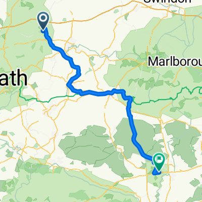
51.493° N -2.216° W to 51.494° N -2.216° W
A cycling route starting in Nettleton, England, United Kingdom.
Overview
About this route
- 1 h 45 min
- Duration
- 42.7 km
- Distance
- 94 m
- Ascent
- 93 m
- Descent
- 24.3 km/h
- Avg. speed
- 135 m
- Avg. speed

Continue with Bikemap
Use, edit, or download this cycling route
You would like to ride 51.493° N -2.216° W to 51.494° N -2.216° W or customize it for your own trip? Here is what you can do with this Bikemap route:
Free features
- Save this route as favorite or in collections
- Copy & plan your own version of this route
- Sync your route with Garmin or Wahoo
Premium features
Free trial for 3 days, or one-time payment. More about Bikemap Premium.
- Navigate this route on iOS & Android
- Export a GPX / KML file of this route
- Create your custom printout (try it for free)
- Download this route for offline navigation
Discover more Premium features.
Get Bikemap PremiumFrom our community
Other popular routes starting in Nettleton
 Cotswold 5, Castle Combe-Stonehenge
- Distance
- 64.1 km
- Ascent
- 269 m
- Descent
- 260 m
- Location
- Nettleton, England, United Kingdom
 Cotswold 5, Castle Combe-Shrewton
- Distance
- 58.6 km
- Ascent
- 274 m
- Descent
- 291 m
- Location
- Nettleton, England, United Kingdom
 Market Place 1, Castle Combe to Beckford Road
- Distance
- 145.2 km
- Ascent
- 292 m
- Descent
- 388 m
- Location
- Nettleton, England, United Kingdom
 Moderate route in Bristol
- Distance
- 17.1 km
- Ascent
- 229 m
- Descent
- 203 m
- Location
- Nettleton, England, United Kingdom
 Ellens Cottage, Market Pl, Chippenham to Frome Railway Station, Station Approach, Frome
- Distance
- 46.7 km
- Ascent
- 651 m
- Descent
- 661 m
- Location
- Nettleton, England, United Kingdom
 Severn Bridge Sportive 100
- Distance
- 163.1 km
- Ascent
- 720 m
- Descent
- 719 m
- Location
- Nettleton, England, United Kingdom
 northeast route
- Distance
- 75.4 km
- Ascent
- 491 m
- Descent
- 491 m
- Location
- Nettleton, England, United Kingdom
 Castle Combe-East Chisenbury
- Distance
- 54.4 km
- Ascent
- 303 m
- Descent
- 315 m
- Location
- Nettleton, England, United Kingdom
Open it in the app