

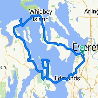
Everett-Snohomish-Monroe-Granite Falls Tour
A cycling route starting in Mukilteo, Washington, United States of America.
Overview
About this route
Ride takes you through scenic East Snohomish County. The East half of this ride is hilly and there is a big hill from Everett down to the Snohomish River Valley.
- -:--
- Duration
- 115.8 km
- Distance
- 548 m
- Ascent
- 544 m
- Descent
- ---
- Avg. speed
- ---
- Avg. speed

Route quality
Waytypes & surfaces along the route
Waytypes
Road
79.1 km
(68 %)
Busy road
14.7 km
(13 %)
Surfaces
Paved
32 km
(28 %)
Asphalt
24.1 km
(21 %)
Paved (undefined)
7.9 km
(7 %)
Continue with Bikemap
Use, edit, or download this cycling route
You would like to ride Everett-Snohomish-Monroe-Granite Falls Tour or customize it for your own trip? Here is what you can do with this Bikemap route:
Free features
- Save this route as favorite or in collections
- Copy & plan your own version of this route
- Sync your route with Garmin or Wahoo
Premium features
Free trial for 3 days, or one-time payment. More about Bikemap Premium.
- Navigate this route on iOS & Android
- Export a GPX / KML file of this route
- Create your custom printout (try it for free)
- Download this route for offline navigation
Discover more Premium features.
Get Bikemap PremiumFrom our community
Other popular routes starting in Mukilteo
 4 Lighthouse Century
- Distance
- 198.8 km
- Ascent
- 945 m
- Descent
- 945 m
- Location
- Mukilteo, Washington, United States of America
 Everett to Lk Washington Loop
- Distance
- 132.8 km
- Ascent
- 643 m
- Descent
- 643 m
- Location
- Mukilteo, Washington, United States of America
 try this
- Distance
- 38.3 km
- Ascent
- 234 m
- Descent
- 284 m
- Location
- Mukilteo, Washington, United States of America
 Paine Field hill route.
- Distance
- 33.7 km
- Ascent
- 432 m
- Descent
- 432 m
- Location
- Mukilteo, Washington, United States of America
 Relaxed route in Mukilteo
- Distance
- 5.7 km
- Ascent
- 218 m
- Descent
- 215 m
- Location
- Mukilteo, Washington, United States of America
 Everett to Skagit County Line via Centennial Trail
- Distance
- 64.8 km
- Ascent
- 248 m
- Descent
- 294 m
- Location
- Mukilteo, Washington, United States of America
 Everett-Maple Valley 4 Trails
- Distance
- 174.4 km
- Ascent
- 458 m
- Descent
- 458 m
- Location
- Mukilteo, Washington, United States of America
 Paine Field Area Hill Ride
- Distance
- 24.3 km
- Ascent
- 352 m
- Descent
- 349 m
- Location
- Mukilteo, Washington, United States of America
Open it in the app