
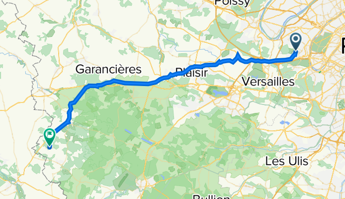
De 4 Rue des 4 Vents, Garches à 1 Place de la Mairie, La Hauteville
A cycling route starting in Saint-Cloud, Île-de-France Region, France.
Overview
About this route
- 3 h 22 min
- Duration
- 53.6 km
- Distance
- 504 m
- Ascent
- 486 m
- Descent
- 15.9 km/h
- Avg. speed
- 193 m
- Avg. speed

Route quality
Waytypes & surfaces along the route
Waytypes
Busy road
38.9 km
(73 %)
Quiet road
7.8 km
(15 %)
Surfaces
Paved
31 km
(58 %)
Unpaved
0.9 km
(2 %)
Asphalt
30.9 km
(58 %)
Gravel
0.8 km
(2 %)
Continue with Bikemap
Use, edit, or download this cycling route
You would like to ride De 4 Rue des 4 Vents, Garches à 1 Place de la Mairie, La Hauteville or customize it for your own trip? Here is what you can do with this Bikemap route:
Free features
- Save this route as favorite or in collections
- Copy & plan your own version of this route
- Sync your route with Garmin or Wahoo
Premium features
Free trial for 3 days, or one-time payment. More about Bikemap Premium.
- Navigate this route on iOS & Android
- Export a GPX / KML file of this route
- Create your custom printout (try it for free)
- Download this route for offline navigation
Discover more Premium features.
Get Bikemap PremiumFrom our community
Other popular routes starting in Saint-Cloud
 St Cloud Bagneux au plus court
- Distance
- 14.3 km
- Ascent
- 126 m
- Descent
- 151 m
- Location
- Saint-Cloud, Île-de-France Region, France
 Ride Rapha
- Distance
- 84.6 km
- Ascent
- 498 m
- Descent
- 499 m
- Location
- Saint-Cloud, Île-de-France Region, France
 Rock En Seine
- Distance
- 16.4 km
- Ascent
- 187 m
- Descent
- 108 m
- Location
- Saint-Cloud, Île-de-France Region, France
 Relaxed route in Paris
- Distance
- 14.3 km
- Ascent
- 119 m
- Descent
- 157 m
- Location
- Saint-Cloud, Île-de-France Region, France
 Tout droit à l'intérieur Boulogne-Billancourt
- Distance
- 8.4 km
- Ascent
- 93 m
- Descent
- 152 m
- Location
- Saint-Cloud, Île-de-France Region, France
 Saint cloud>> les petites dalles
- Distance
- 190.4 km
- Ascent
- 720 m
- Descent
- 803 m
- Location
- Saint-Cloud, Île-de-France Region, France
 Saint Cloud to Issy
- Distance
- 8.1 km
- Ascent
- 38 m
- Descent
- 108 m
- Location
- Saint-Cloud, Île-de-France Region, France
 PSC-TST-001
- Distance
- 163.5 km
- Ascent
- 558 m
- Descent
- 556 m
- Location
- Saint-Cloud, Île-de-France Region, France
Open it in the app