

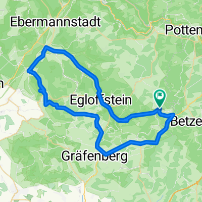
Kleingesee-Weinstraße 47, Gößweinstein nach Kleingesee-Weinstraße 47, Gößweinstein
A cycling route starting in Obertrubach, Bavaria, Germany.
Overview
About this route
- 9 h 2 min
- Duration
- 75.7 km
- Distance
- 1,000 m
- Ascent
- 997 m
- Descent
- 8.4 km/h
- Avg. speed
- 554 m
- Avg. speed

Route quality
Waytypes & surfaces along the route
Waytypes
Track
32.2 km
(43 %)
Quiet road
18.1 km
(24 %)
Surfaces
Paved
40.9 km
(54 %)
Unpaved
20.8 km
(27 %)
Asphalt
32.9 km
(44 %)
Gravel
16.3 km
(21 %)
Continue with Bikemap
Use, edit, or download this cycling route
You would like to ride Kleingesee-Weinstraße 47, Gößweinstein nach Kleingesee-Weinstraße 47, Gößweinstein or customize it for your own trip? Here is what you can do with this Bikemap route:
Free features
- Save this route as favorite or in collections
- Copy & plan your own version of this route
- Sync your route with Garmin or Wahoo
Premium features
Free trial for 3 days, or one-time payment. More about Bikemap Premium.
- Navigate this route on iOS & Android
- Export a GPX / KML file of this route
- Create your custom printout (try it for free)
- Download this route for offline navigation
Discover more Premium features.
Get Bikemap PremiumFrom our community
Other popular routes starting in Obertrubach
 Obertrubach - Pottenstein
- Distance
- 46.1 km
- Ascent
- 729 m
- Descent
- 747 m
- Location
- Obertrubach, Bavaria, Germany
 Obertrubach - Ebermannstadt
- Distance
- 75.3 km
- Ascent
- 816 m
- Descent
- 831 m
- Location
- Obertrubach, Bavaria, Germany
 Betzenstein – Obertrubach – Betzenstein
- Distance
- 17.8 km
- Ascent
- 400 m
- Descent
- 397 m
- Location
- Obertrubach, Bavaria, Germany
 Tour 2 Walberla
- Distance
- 55.9 km
- Ascent
- 616 m
- Descent
- 616 m
- Location
- Obertrubach, Bavaria, Germany
 kleine fränkische Runde
- Distance
- 40.1 km
- Ascent
- 619 m
- Descent
- 620 m
- Location
- Obertrubach, Bavaria, Germany
 Anstieg Wolfsberg Geschwand
- Distance
- 3.4 km
- Ascent
- 191 m
- Descent
- 46 m
- Location
- Obertrubach, Bavaria, Germany
 Obertrubach RF
- Distance
- 20.2 km
- Ascent
- 402 m
- Descent
- 404 m
- Location
- Obertrubach, Bavaria, Germany
 Betzenstein_-_Obertrubach_-_Betzenstein - Betzenstein_-_Obertrubach_-_Betzenstein
- Distance
- 37.2 km
- Ascent
- 782 m
- Descent
- 784 m
- Location
- Obertrubach, Bavaria, Germany
Open it in the app