
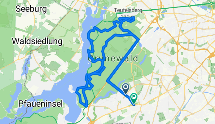
Crossrunde im Grunewald
A cycling route starting in Zehlendorf, Land Berlin, Germany.
Overview
About this route
Hügelige Crossrunde im Grunewald mit Teufelsberg, Havelberg und noch ein paar anderen Wellen:-))
- -:--
- Duration
- 46.4 km
- Distance
- 349 m
- Ascent
- 343 m
- Descent
- ---
- Avg. speed
- 87 m
- Avg. speed
Route quality
Waytypes & surfaces along the route
Waytypes
Track
23.2 km
(50 %)
Path
12.3 km
(27 %)
Surfaces
Paved
17.4 km
(37 %)
Unpaved
26.3 km
(57 %)
Asphalt
16.1 km
(35 %)
Ground
14.4 km
(31 %)
Continue with Bikemap
Use, edit, or download this cycling route
You would like to ride Crossrunde im Grunewald or customize it for your own trip? Here is what you can do with this Bikemap route:
Free features
- Save this route as favorite or in collections
- Copy & plan your own version of this route
- Sync your route with Garmin or Wahoo
Premium features
Free trial for 3 days, or one-time payment. More about Bikemap Premium.
- Navigate this route on iOS & Android
- Export a GPX / KML file of this route
- Create your custom printout (try it for free)
- Download this route for offline navigation
Discover more Premium features.
Get Bikemap PremiumFrom our community
Other popular routes starting in Zehlendorf
 S Zehlendorf -> Tremsdorf -> Caputh -> Auerbachtunnel
- Distance
- 65.4 km
- Ascent
- 258 m
- Descent
- 245 m
- Location
- Zehlendorf, Land Berlin, Germany
 Berlin - Dobbrikow - Fläming - Jüterbog - Berlin
- Distance
- 156.8 km
- Ascent
- 378 m
- Descent
- 381 m
- Location
- Zehlendorf, Land Berlin, Germany
 RTF 24. Eichh. 2. Runde
- Distance
- 40.5 km
- Ascent
- 112 m
- Descent
- 116 m
- Location
- Zehlendorf, Land Berlin, Germany
 grunerunde
- Distance
- 31.4 km
- Ascent
- 181 m
- Descent
- 178 m
- Location
- Zehlendorf, Land Berlin, Germany
 Berliner Mauerweg
- Distance
- 172.8 km
- Ascent
- 175 m
- Descent
- 181 m
- Location
- Zehlendorf, Land Berlin, Germany
 Dobbrikow andersrum
- Distance
- 111.2 km
- Ascent
- 139 m
- Descent
- 133 m
- Location
- Zehlendorf, Land Berlin, Germany
 Dahlem Route
- Distance
- 15.8 km
- Ascent
- 49 m
- Descent
- 52 m
- Location
- Zehlendorf, Land Berlin, Germany
 Zehlendorf -> Trebbin
- Distance
- 72.6 km
- Ascent
- 96 m
- Descent
- 95 m
- Location
- Zehlendorf, Land Berlin, Germany
Open it in the app