

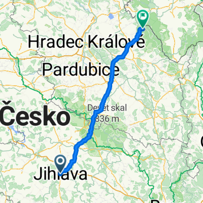
28.maj
A cycling route starting in Jihlava, Kraj Vysočina, Czechia.
Overview
About this route
- -:--
- Duration
- 36.6 km
- Distance
- 531 m
- Ascent
- 566 m
- Descent
- ---
- Avg. speed
- 670 m
- Avg. speed

Route quality
Waytypes & surfaces along the route
Waytypes
Quiet road
13.3 km
(36 %)
Busy road
8 km
(22 %)
Surfaces
Paved
6.3 km
(17 %)
Unpaved
2.2 km
(6 %)
Asphalt
6.3 km
(17 %)
Gravel
2.2 km
(6 %)
Undefined
28.2 km
(77 %)
Route highlights
Points of interest along the route
Point of interest after 16.6 km
Kostel sv. Rodiny
Continue with Bikemap
Use, edit, or download this cycling route
You would like to ride 28.maj or customize it for your own trip? Here is what you can do with this Bikemap route:
Free features
- Save this route as favorite or in collections
- Copy & plan your own version of this route
- Sync your route with Garmin or Wahoo
Premium features
Free trial for 3 days, or one-time payment. More about Bikemap Premium.
- Navigate this route on iOS & Android
- Export a GPX / KML file of this route
- Create your custom printout (try it for free)
- Download this route for offline navigation
Discover more Premium features.
Get Bikemap PremiumFrom our community
Other popular routes starting in Jihlava
 Jihlava - Pavlov u Herálce (lom)
- Distance
- 21.5 km
- Ascent
- 364 m
- Descent
- 286 m
- Location
- Jihlava, Kraj Vysočina, Czechia
 Jihlava to Uhlířské Janovice
- Distance
- 93.5 km
- Ascent
- 1,553 m
- Descent
- 1,651 m
- Location
- Jihlava, Kraj Vysočina, Czechia
 Brtnická, Йиглава до Sídliště Vajgar, Йиндржихув-Градец
- Distance
- 70.8 km
- Ascent
- 1,056 m
- Descent
- 1,090 m
- Location
- Jihlava, Kraj Vysočina, Czechia
 Jihlava-Staré Město-Jihlava
- Distance
- 86.4 km
- Ascent
- 1,454 m
- Descent
- 1,427 m
- Location
- Jihlava, Kraj Vysočina, Czechia
 jihlava
- Distance
- 22.9 km
- Ascent
- 251 m
- Descent
- 251 m
- Location
- Jihlava, Kraj Vysočina, Czechia
 JIhlava - Popice - Cerekvička - Luka nad Jihlava - JIhlava
- Distance
- 45.5 km
- Ascent
- 0 m
- Descent
- 0 m
- Location
- Jihlava, Kraj Vysočina, Czechia
 Jihlava-dolni_smrcne-VBeranov
- Distance
- 38 km
- Ascent
- 518 m
- Descent
- 497 m
- Location
- Jihlava, Kraj Vysočina, Czechia
 Jihlava - Deštné v O.h. Zákoutí
- Distance
- 139.2 km
- Ascent
- 1,365 m
- Descent
- 1,395 m
- Location
- Jihlava, Kraj Vysočina, Czechia
Open it in the app