

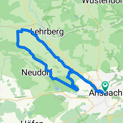
Ansbacher Hohenzollernrunde
A cycling route starting in Ansbach, Bavaria, Germany.
Overview
About this route
Landkreisempfehlung Stromtreter
- -:--
- Duration
- 78.8 km
- Distance
- 697 m
- Ascent
- 697 m
- Descent
- ---
- Avg. speed
- 471 m
- Avg. speed

Route quality
Waytypes & surfaces along the route
Waytypes
Quiet road
31.4 km
(40 %)
Track
19.6 km
(25 %)
Surfaces
Paved
55.1 km
(70 %)
Unpaved
6 km
(8 %)
Asphalt
46.9 km
(59 %)
Gravel
5.1 km
(6 %)
Route highlights
Points of interest along the route
Point of interest after 29.9 km
Stellplatz für PKW
Continue with Bikemap
Use, edit, or download this cycling route
You would like to ride Ansbacher Hohenzollernrunde or customize it for your own trip? Here is what you can do with this Bikemap route:
Free features
- Save this route as favorite or in collections
- Copy & plan your own version of this route
- Sync your route with Garmin or Wahoo
Premium features
Free trial for 3 days, or one-time payment. More about Bikemap Premium.
- Navigate this route on iOS & Android
- Export a GPX / KML file of this route
- Create your custom printout (try it for free)
- Download this route for offline navigation
Discover more Premium features.
Get Bikemap PremiumFrom our community
Other popular routes starting in Ansbach
 MTB Tour, Ansbach Nord CLONED FROM ROUTE 1606766
- Distance
- 24.2 km
- Ascent
- 298 m
- Descent
- 300 m
- Location
- Ansbach, Bavaria, Germany
 Sonntag Morgen
- Distance
- 72.7 km
- Ascent
- 344 m
- Descent
- 345 m
- Location
- Ansbach, Bavaria, Germany
 MTB --> tgl. Bassistraining
- Distance
- 22.6 km
- Ascent
- 103 m
- Descent
- 105 m
- Location
- Ansbach, Bavaria, Germany
 Südwestlicher Landkreis Ansbach
- Distance
- 41.7 km
- Ascent
- 119 m
- Descent
- 173 m
- Location
- Ansbach, Bavaria, Germany
 Feierabendrunde 1
- Distance
- 24.9 km
- Ascent
- 185 m
- Descent
- 182 m
- Location
- Ansbach, Bavaria, Germany
 Tour südlich um Ansbach herum
- Distance
- 58.8 km
- Ascent
- 262 m
- Descent
- 262 m
- Location
- Ansbach, Bavaria, Germany
 Ansbach - Altmühlsee u. zurück
- Distance
- 51.7 km
- Ascent
- 216 m
- Descent
- 216 m
- Location
- Ansbach, Bavaria, Germany
 Ansbacher Powerrunde
- Distance
- 31.3 km
- Ascent
- 328 m
- Descent
- 325 m
- Location
- Ansbach, Bavaria, Germany
Open it in the app