
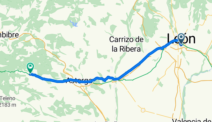
CaminoSantiago Leon-Rabanal del Camino
A cycling route starting in León, Castille and León, Spain.
Overview
About this route
Indice IBP 77BC
Fecha 27-06-2011
- -:--
- Duration
- 72 km
- Distance
- 578 m
- Ascent
- 249 m
- Descent
- ---
- Avg. speed
- ---
- Avg. speed
Route quality
Waytypes & surfaces along the route
Waytypes
Track
18.7 km
(26 %)
Quiet road
15.2 km
(21 %)
Surfaces
Paved
24.2 km
(34 %)
Unpaved
8.7 km
(12 %)
Asphalt
19.5 km
(27 %)
Unpaved (undefined)
5.9 km
(8 %)
Continue with Bikemap
Use, edit, or download this cycling route
You would like to ride CaminoSantiago Leon-Rabanal del Camino or customize it for your own trip? Here is what you can do with this Bikemap route:
Free features
- Save this route as favorite or in collections
- Copy & plan your own version of this route
- Sync your route with Garmin or Wahoo
Premium features
Free trial for 3 days, or one-time payment. More about Bikemap Premium.
- Navigate this route on iOS & Android
- Export a GPX / KML file of this route
- Create your custom printout (try it for free)
- Download this route for offline navigation
Discover more Premium features.
Get Bikemap PremiumFrom our community
Other popular routes starting in León
 74 km. ruta de las Omañas
- Distance
- 74.4 km
- Ascent
- 632 m
- Descent
- 694 m
- Location
- León, Castille and León, Spain
 León-Villaturiel-Villarroañe-León
- Distance
- 41.7 km
- Ascent
- 132 m
- Descent
- 132 m
- Location
- León, Castille and León, Spain
 LEON-LORENZANA-CUADROS-LA ROBLA-SANTA LUCIA-LA VID-VEGACERVERA-ROBLES-GARRAFE-LEON
- Distance
- 87.2 km
- Ascent
- 549 m
- Descent
- 532 m
- Location
- León, Castille and León, Spain
 León-Montejos-San Miguel C.-Fresno C.-León
- Distance
- 40.2 km
- Ascent
- 268 m
- Descent
- 268 m
- Location
- León, Castille and León, Spain
 Por el Bernesga y el Torío
- Distance
- 36.4 km
- Ascent
- 278 m
- Descent
- 278 m
- Location
- León, Castille and León, Spain
 León-Villaverde de arriba-León
- Distance
- 35.9 km
- Ascent
- 227 m
- Descent
- 227 m
- Location
- León, Castille and León, Spain
 67 km. ruta de ermita del Buen Suceso.
- Distance
- 66.9 km
- Ascent
- 470 m
- Descent
- 511 m
- Location
- León, Castille and León, Spain
 San Andres, Montejos, Aeropuerto, La Virgen, Oteruelo, Armunia;Candamia
- Distance
- 33.7 km
- Ascent
- 197 m
- Descent
- 197 m
- Location
- León, Castille and León, Spain
Open it in the app