

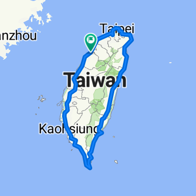
環島預計路線圖
A cycling route starting in Hsinchu, Taiwan, Taiwan.
Overview
About this route
第一天、台一線(新竹→台中)
第二天、台一線(台中→彰化)
第三天、台一線(彰化→嘉義)
第四天、台一線(嘉義→高雄)
第五天、台一線+199縣道(高雄→台東)
第六天、台9線(台東→花蓮瑞穗)
第七天、台9線(花蓮瑞穗→花蓮市)
第八天、台9線(花蓮市→宜蘭蘇澳)
第九天、台2線+台5線(宜蘭蘇澳→台北)
第十天、台1線(台北→新竹)
第十一天、[陸續更新,以上規劃僅供參考]
第十二天、
第十三天、
第十四天、
- -:--
- Duration
- 987.8 km
- Distance
- 1,534 m
- Ascent
- 1,534 m
- Descent
- ---
- Avg. speed
- ---
- Avg. speed
Continue with Bikemap
Use, edit, or download this cycling route
You would like to ride 環島預計路線圖 or customize it for your own trip? Here is what you can do with this Bikemap route:
Free features
- Save this route as favorite or in collections
- Copy & plan your own version of this route
- Sync your route with Garmin or Wahoo
Premium features
Free trial for 3 days, or one-time payment. More about Bikemap Premium.
- Navigate this route on iOS & Android
- Export a GPX / KML file of this route
- Create your custom printout (try it for free)
- Download this route for offline navigation
Discover more Premium features.
Get Bikemap PremiumFrom our community
Other popular routes starting in Hsinchu
 20200822父子倆騎行17公里中段
- Distance
- 5.5 km
- Ascent
- 0 m
- Descent
- 3 m
- Location
- Hsinchu, Taiwan, Taiwan
 新竹-羅馬公路-大溪
- Distance
- 118.5 km
- Ascent
- 2,929 m
- Descent
- 2,854 m
- Location
- Hsinchu, Taiwan, Taiwan
 新埔-太平窩 (Shinpu)
- Distance
- 45 km
- Ascent
- 483 m
- Descent
- 471 m
- Location
- Hsinchu, Taiwan, Taiwan
 教育大學_新城_水流東_永和山水庫_台一線
- Distance
- 51.3 km
- Ascent
- 492 m
- Descent
- 492 m
- Location
- Hsinchu, Taiwan, Taiwan
 二寮神木 (Beipu)
- Distance
- 43.9 km
- Ascent
- 618 m
- Descent
- 617 m
- Location
- Hsinchu, Taiwan, Taiwan
 環島I
環島I- Distance
- 1,115.9 km
- Ascent
- 1,758 m
- Descent
- 1,758 m
- Location
- Hsinchu, Taiwan, Taiwan
 新竹17公里海岸
- Distance
- 37 km
- Ascent
- 51 m
- Descent
- 49 m
- Location
- Hsinchu, Taiwan, Taiwan
 20070430_峨嵋湖
- Distance
- 11.6 km
- Ascent
- 203 m
- Descent
- 186 m
- Location
- Hsinchu, Taiwan, Taiwan
Open it in the app