

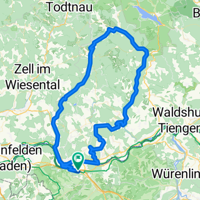
Bad Säckingen - Staffelegg - Aarau
A cycling route starting in Stein, Canton of Aargau, Switzerland.
Overview
About this route
Schöne Strecke. Den Rhein über die alte Holzbrücke in Bad Säckingen überqueren, dann langsam und entspannt Richtung Frick aufwärts. Zum Ende hin anspruchsvolle Jura-Steigung zur Staffelegg. Ab Asp teilweise knackig. Oben wunderbares Panorama über Wiesen und Höfe ins Aaretal. Rasante Abfahrt. In der Gegenrichtung ein Traum. Harte Anstieg zur Staffelegg, danach entspanntes Rollen- oder zügiges Laufenlassen bis runter an den Rhein.
- -:--
- Duration
- 27.6 km
- Distance
- 418 m
- Ascent
- 321 m
- Descent
- ---
- Avg. speed
- ---
- Avg. speed

Route quality
Waytypes & surfaces along the route
Waytypes
Quiet road
9.2 km
(34 %)
Busy road
8.6 km
(31 %)
Surfaces
Paved
23 km
(83 %)
Unpaved
0.3 km
(<1 %)
Asphalt
22 km
(80 %)
Paving stones
0.8 km
(3 %)
Continue with Bikemap
Use, edit, or download this cycling route
You would like to ride Bad Säckingen - Staffelegg - Aarau or customize it for your own trip? Here is what you can do with this Bikemap route:
Free features
- Save this route as favorite or in collections
- Copy & plan your own version of this route
- Sync your route with Garmin or Wahoo
Premium features
Free trial for 3 days, or one-time payment. More about Bikemap Premium.
- Navigate this route on iOS & Android
- Export a GPX / KML file of this route
- Create your custom printout (try it for free)
- Download this route for offline navigation
Discover more Premium features.
Get Bikemap PremiumFrom our community
Other popular routes starting in Stein
 Gippingen - Buch - Niederwihl
- Distance
- 80.1 km
- Ascent
- 779 m
- Descent
- 780 m
- Location
- Stein, Canton of Aargau, Switzerland
 Gippingen - Mandach - Gansingen - Sulz
- Distance
- 62.4 km
- Ascent
- 625 m
- Descent
- 625 m
- Location
- Stein, Canton of Aargau, Switzerland
 Fisibach-Schneisingen-Gansingen
- Distance
- 106.8 km
- Ascent
- 687 m
- Descent
- 687 m
- Location
- Stein, Canton of Aargau, Switzerland
 19,04.19 venerdi pascqua 👍
- Distance
- 31.4 km
- Ascent
- 119 m
- Descent
- 119 m
- Location
- Stein, Canton of Aargau, Switzerland
 Vorschlag Route sehr schön, wenig Verkehr
- Distance
- 80.7 km
- Ascent
- 2,565 m
- Descent
- 2,606 m
- Location
- Stein, Canton of Aargau, Switzerland
 Wehr - Todtmoos - Bernau - Tiefenstein - Oberwihl - Murg
- Distance
- 109.1 km
- Ascent
- 1,179 m
- Descent
- 1,179 m
- Location
- Stein, Canton of Aargau, Switzerland
 Bad Säckingen Rheinroute Waldshut
- Distance
- 59.7 km
- Ascent
- 469 m
- Descent
- 472 m
- Location
- Stein, Canton of Aargau, Switzerland
 2TT/2016 Bad Säckingen - Bern
- Distance
- 114 km
- Ascent
- 860 m
- Descent
- 605 m
- Location
- Stein, Canton of Aargau, Switzerland
Open it in the app