

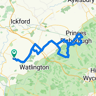
Stadhampton to Piss Hill back to Stad.
A cycling route starting in Chalgrove, England, United Kingdom.
Overview
About this route
Best Bike - Gravel, in the dry OK on any bike but racers. Refreshments: Route passes close to several Pubs BP/M&S in Stadhampton. Parking: Stadhampton Common by the Church.
Route: From Stadhampton (park on the common by the church) to Lexknor, via Chalgrove. A40 climb (2 lanes up,1 down very little used by vehicles thanks to M40 to Christmas Common, downhill off-road to Stonor. Sharp back towards Stad via Piss Hill, decent to Britwell Salome via the straight and very fast Britwell Hill. A bit more off-road to reach Chalgrove then back to Stad via Berick Prior.
- -:--
- Duration
- 51.2 km
- Distance
- 511 m
- Ascent
- 513 m
- Descent
- ---
- Avg. speed
- 258 m
- Avg. speed

Route quality
Waytypes & surfaces along the route
Waytypes
Road
20.1 km
(39 %)
Busy road
16 km
(31 %)
Surfaces
Paved
4.7 km
(9 %)
Unpaved
1.8 km
(3 %)
Asphalt
4.7 km
(9 %)
Gravel
1.8 km
(3 %)
Undefined
44.7 km
(87 %)
Continue with Bikemap
Use, edit, or download this cycling route
You would like to ride Stadhampton to Piss Hill back to Stad. or customize it for your own trip? Here is what you can do with this Bikemap route:
Free features
- Save this route as favorite or in collections
- Copy & plan your own version of this route
- Sync your route with Garmin or Wahoo
Premium features
Free trial for 3 days, or one-time payment. More about Bikemap Premium.
- Navigate this route on iOS & Android
- Export a GPX / KML file of this route
- Create your custom printout (try it for free)
- Download this route for offline navigation
Discover more Premium features.
Get Bikemap PremiumFrom our community
Other popular routes starting in Chalgrove
 Stad to Rnas 815, Yeovilton
- Distance
- 170.3 km
- Ascent
- 1,315 m
- Descent
- 1,351 m
- Location
- Chalgrove, England, United Kingdom
 wills wild ride
- Distance
- 33.9 km
- Ascent
- 169 m
- Descent
- 175 m
- Location
- Chalgrove, England, United Kingdom
 Chinnor and Kopp Hill from Chalgrove
- Distance
- 65.5 km
- Ascent
- 572 m
- Descent
- 569 m
- Location
- Chalgrove, England, United Kingdom
 bike tour from Stad'm
- Distance
- 18.2 km
- Ascent
- 60 m
- Descent
- 57 m
- Location
- Chalgrove, England, United Kingdom
 pub walk
- Distance
- 4.4 km
- Ascent
- 232 m
- Descent
- 220 m
- Location
- Chalgrove, England, United Kingdom
 7 Horse Close Cottages, Oxford to 1–11 Hardings, Chalgrove, Oxford
- Distance
- 7.9 km
- Ascent
- 20 m
- Descent
- 32 m
- Location
- Chalgrove, England, United Kingdom
 Stadhampton to Piss Hill back to Stad.
- Distance
- 51.2 km
- Ascent
- 511 m
- Descent
- 513 m
- Location
- Chalgrove, England, United Kingdom
 Stadampton Xmas Common loop
- Distance
- 43.5 km
- Ascent
- 265 m
- Descent
- 264 m
- Location
- Chalgrove, England, United Kingdom
Open it in the app