

Lord Nelson/Shaldon/Humber
A cycling route starting in Kingskerswell, England, United Kingdom.
Overview
About this route
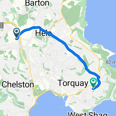
Lord Nelson, up Fluder Hill, Great Hill, To Rocombe and on to Coombe-in-Teignhead, Shaldon, Bishopsteignton, Humber, Kingsteignton, Towards MT Tmsb, B&Q, back main Kerswell Road
- -:--
- Duration
- 30.1 km
- Distance
- 430 m
- Ascent
- 447 m
- Descent
- ---
- Avg. speed
- 161 m
- Avg. speed
Route quality
Waytypes & surfaces along the route
Waytypes
Quiet road
17.2 km
(57 %)
Road
5.4 km
(18 %)
Surfaces
Paved
16.8 km
(56 %)
Asphalt
16.8 km
(56 %)
Paved (undefined)
0 km
(<1 %)
Undefined
13.3 km
(44 %)
Continue with Bikemap
Use, edit, or download this cycling route
You would like to ride Lord Nelson/Shaldon/Humber or customize it for your own trip? Here is what you can do with this Bikemap route:
Free features
- Save this route as favorite or in collections
- Copy & plan your own version of this route
- Sync your route with Garmin or Wahoo
Premium features
Free trial for 3 days, or one-time payment. More about Bikemap Premium.
- Navigate this route on iOS & Android
- Export a GPX / KML file of this route
- Create your custom printout (try it for free)
- Download this route for offline navigation
Discover more Premium features.
Get Bikemap PremiumFrom our community
Other popular routes starting in Kingskerswell
 Kingsteignton
- Distance
- 7 km
- Ascent
- 26 m
- Descent
- 58 m
- Location
- Kingskerswell, England, United Kingdom
 Home
Home- Distance
- 4.8 km
- Ascent
- 110 m
- Descent
- 85 m
- Location
- Kingskerswell, England, United Kingdom
 Route to The Park Inn
- Distance
- 24.6 km
- Ascent
- 421 m
- Descent
- 421 m
- Location
- Kingskerswell, England, United Kingdom
 kingskerwell to killerton
- Distance
- 91.5 km
- Ascent
- 556 m
- Descent
- 494 m
- Location
- Kingskerswell, England, United Kingdom
 Bay Loop
- Distance
- 28.9 km
- Ascent
- 305 m
- Descent
- 309 m
- Location
- Kingskerswell, England, United Kingdom
 buckfastleigh
- Distance
- 19.9 km
- Ascent
- 298 m
- Descent
- 299 m
- Location
- Kingskerswell, England, United Kingdom
 Recovered Route
- Distance
- 10.7 km
- Ascent
- 125 m
- Descent
- 137 m
- Location
- Kingskerswell, England, United Kingdom
 100 Miles in 8/10 hours 20 Sep 2009
- Distance
- 155.7 km
- Ascent
- 798 m
- Descent
- 798 m
- Location
- Kingskerswell, England, United Kingdom
Open it in the app