

Glantalrunde
A cycling route starting in Glanegg, Carinthia, Austria.
Overview
About this route
Streckenführung:<br />Ingelsdorf - Briefelsdorf - Kallitsch - Fasching - Untere Glan - B95 Richtung Glanegg - Mautbrücken - Glantscha - L70A Flatschacher Landesstraße - Flatschach - Faning - Windischbach - Tigringer Straße - Wielen - Schrimitzerstraße - Klein St. Veit - Ingelsdorf
Einkehrmöglichkeit:
Gasthof Mark, Klein St. Veit<br />Gasthof Uhr, Klein St. Veit
- -:--
- Duration
- 21.5 km
- Distance
- 262 m
- Ascent
- 262 m
- Descent
- ---
- Avg. speed
- ---
- Avg. speed

Route quality
Waytypes & surfaces along the route
Waytypes
Busy road
17.7 km
(82 %)
Quiet road
1.8 km
(8 %)
Surfaces
Paved
8.7 km
(41 %)
Unpaved
0.4 km
(2 %)
Asphalt
8.7 km
(41 %)
Ground
0.4 km
(2 %)
Route highlights
Points of interest along the route
Point of interest after 21.3 km
Kramerwirt Wilfried Uhr Klein St. Veit 4 9560 Feldkirchen in Kärnten Telefon: +43 4277 29097
Point of interest after 21.3 km
Gast- und Landwirt Mark Alois Klein St. Veit 12 9560 Feldkirchen in Kärnten Telefon: +43 4277 26 66
Continue with Bikemap
Use, edit, or download this cycling route
You would like to ride Glantalrunde or customize it for your own trip? Here is what you can do with this Bikemap route:
Free features
- Save this route as favorite or in collections
- Copy & plan your own version of this route
- Sync your route with Garmin or Wahoo
Premium features
Free trial for 3 days, or one-time payment. More about Bikemap Premium.
- Navigate this route on iOS & Android
- Export a GPX / KML file of this route
- Create your custom printout (try it for free)
- Download this route for offline navigation
Discover more Premium features.
Get Bikemap PremiumFrom our community
Other popular routes starting in Glanegg
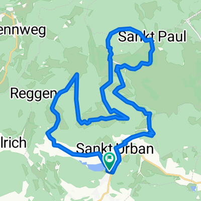 St. Urban- vom See übern Berg zum See. CLONED FROM ROUTE 274133
- Distance
- 21 km
- Ascent
- 689 m
- Descent
- 689 m
- Location
- Glanegg, Carinthia, Austria
 Feldkirchen-Runde
- Distance
- 31.6 km
- Ascent
- 518 m
- Descent
- 518 m
- Location
- Glanegg, Carinthia, Austria
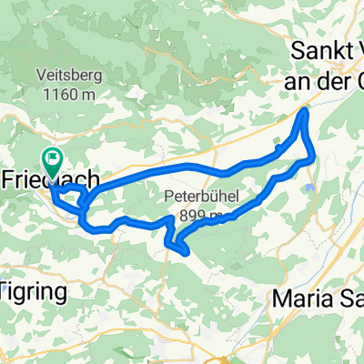
 Friedlach 57 nach Friedlach Bundesstraße/Abzw Ort, Glanegg
- Distance
- 32.3 km
- Ascent
- 123 m
- Descent
- 131 m
- Location
- Glanegg, Carinthia, Austria
 Einfache Fahrt in Sankt Urban
- Distance
- 22 km
- Ascent
- 725 m
- Descent
- 677 m
- Location
- Glanegg, Carinthia, Austria
 Lorenzibergtour
- Distance
- 44.3 km
- Ascent
- 942 m
- Descent
- 924 m
- Location
- Glanegg, Carinthia, Austria
 Wölfnitz Ossicher See
- Distance
- 76.1 km
- Ascent
- 404 m
- Descent
- 406 m
- Location
- Glanegg, Carinthia, Austria
 Wölfnitz Simonhöhe Wölfnitz
- Distance
- 45 km
- Ascent
- 960 m
- Descent
- 960 m
- Location
- Glanegg, Carinthia, Austria
 Friedlach 57 nach Friedlach 12
- Distance
- 33 km
- Ascent
- 474 m
- Descent
- 430 m
- Location
- Glanegg, Carinthia, Austria
Open it in the app