Premium Badge Download on the App Store Get it on Google Play Turn-by-turn Navigation Offline Maps Bike Type Optimized Routing Premium Maps Custom Bike Computer Export Routes Route Previews Fall Detection Premium Support

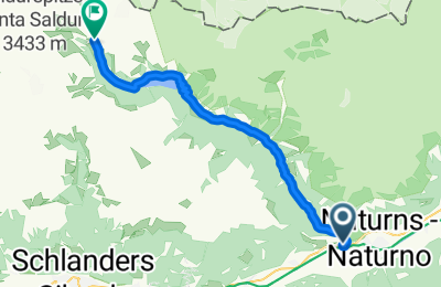
Cycling Route in Naturns, Trentino-Alto Adige, Italy

Schnalstal

0
Open this route in the Bikemap app

Open this route in the Bikemap app

Open this route in Bikemap Web

Open this route in Bikemap Web

24 km
Distance
1625 m
Ascent
165 m
Descent
-:-- h
Duration
-- km/h
Avg. Speed
--- m
Max. Elevation

About This Route

Es empfieht sich Beleuchtung am Fahrrad zu haben, da gleich am Anfang des Tals, ein 1,6km langer Tunnel zu durchfahren ist. Der Anstieg ist schlimmer als er aussieht, da man ständig neben den gemäßigten Steigungungen, mit + 10% konfrontiert wird. Ab Madonna wird das ganze auch landschaftlich attracktiv. Volles Grün im Kontrast zum türkisblauen Wasser des Stausees.

This cycling route is ideal for: Road bike

You will cycle on the following surfaces: Paved

Customize this cycling route with the Bikemap route planner.

Make it yours!

Did you know? You can use this route as a template in our cycling route planner if you don't wish to start from scratch. Customize it based on your needs to plan your perfect cycling tour.

Open it in the app