

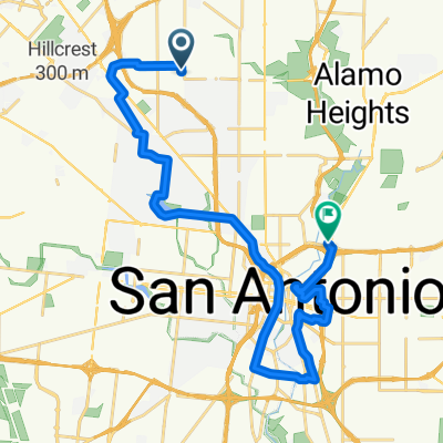
De U.S. 87 Bus 8726, San Antonio a Fredericksburg Road 9400, San Antonio
A cycling route starting in Balcones Heights, Texas, United States of America.
Overview
About this route
- 38 min
- Duration
- 10.4 km
- Distance
- 69 m
- Ascent
- 78 m
- Descent
- 16.3 km/h
- Avg. speed
- 313 m
- Avg. speed

Continue with Bikemap
Use, edit, or download this cycling route
You would like to ride De U.S. 87 Bus 8726, San Antonio a Fredericksburg Road 9400, San Antonio or customize it for your own trip? Here is what you can do with this Bikemap route:
Free features
- Save this route as favorite or in collections
- Copy & plan your own version of this route
- Sync your route with Garmin or Wahoo
Premium features
Free trial for 3 days, or one-time payment. More about Bikemap Premium.
- Navigate this route on iOS & Android
- Export a GPX / KML file of this route
- Create your custom printout (try it for free)
- Download this route for offline navigation
Discover more Premium features.
Get Bikemap PremiumFrom our community
Other popular routes starting in Balcones Heights
 Atx
Atx- Distance
- 9.2 km
- Ascent
- 35 m
- Descent
- 35 m
- Location
- Balcones Heights, Texas, United States of America
 ANS-55km
- Distance
- 55.5 km
- Ascent
- 260 m
- Descent
- 252 m
- Location
- Balcones Heights, Texas, United States of America
 bike tour through San Antonio
- Distance
- 27.9 km
- Ascent
- 64 m
- Descent
- 94 m
- Location
- Balcones Heights, Texas, United States of America
 my work
- Distance
- 6.4 km
- Ascent
- 107 m
- Descent
- 31 m
- Location
- Balcones Heights, Texas, United States of America
 Solo Bro
- Distance
- 15.3 km
- Ascent
- 90 m
- Descent
- 92 m
- Location
- Balcones Heights, Texas, United States of America
 Woodlawn Trails
- Distance
- 8.2 km
- Ascent
- 34 m
- Descent
- 30 m
- Location
- Balcones Heights, Texas, United States of America
 De U.S. 87 Bus 8726, San Antonio a Fredericksburg Road 9400, San Antonio
- Distance
- 10.4 km
- Ascent
- 69 m
- Descent
- 78 m
- Location
- Balcones Heights, Texas, United States of America
 creek to la b
- Distance
- 20.6 km
- Ascent
- 221 m
- Descent
- 223 m
- Location
- Balcones Heights, Texas, United States of America
Open it in the app