
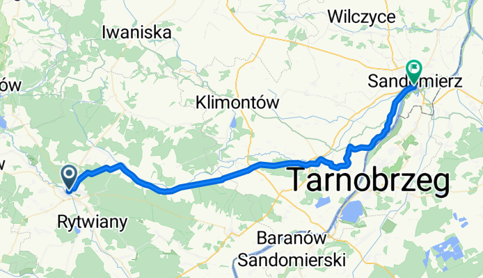
Staszów-Sandomierz
A cycling route starting in Staszów, Świętokrzyskie Voivodship, Poland.
Overview
About this route
Bezpieczna trasa ze Staszowa do Sandomierza, uwaga w Pocieszce jedziemy do końca asfaltu we wsi a potem wjeżdzamy w las. W lesie prosto aż wyjedziemy z lasu w Józefowie na drogę asfaltową. W Józefowie w prawo do skrzyżowania potem w lewo w stronę Wiśniowej.
- -:--
- Duration
- 52.8 km
- Distance
- 107 m
- Ascent
- 150 m
- Descent
- ---
- Avg. speed
- ---
- Avg. speed
Continue with Bikemap
Use, edit, or download this cycling route
You would like to ride Staszów-Sandomierz or customize it for your own trip? Here is what you can do with this Bikemap route:
Free features
- Save this route as favorite or in collections
- Copy & plan your own version of this route
- Sync your route with Garmin or Wahoo
Premium features
Free trial for 3 days, or one-time payment. More about Bikemap Premium.
- Navigate this route on iOS & Android
- Export a GPX / KML file of this route
- Create your custom printout (try it for free)
- Download this route for offline navigation
Discover more Premium features.
Get Bikemap PremiumFrom our community
Other popular routes starting in Staszów
 staszów 2
- Distance
- 46.3 km
- Ascent
- 320 m
- Descent
- 320 m
- Location
- Staszów, Świętokrzyskie Voivodship, Poland
 11 Listopada 161B, Staszów do 11 Listopada 161C, Staszów
- Distance
- 6.4 km
- Ascent
- 166 m
- Descent
- 165 m
- Location
- Staszów, Świętokrzyskie Voivodship, Poland
 wisła
wisła- Distance
- 26 km
- Ascent
- 89 m
- Descent
- 128 m
- Location
- Staszów, Świętokrzyskie Voivodship, Poland
 staszów 1
- Distance
- 51.2 km
- Ascent
- 342 m
- Descent
- 340 m
- Location
- Staszów, Świętokrzyskie Voivodship, Poland
 Staszów-Sandomierz
- Distance
- 52.8 km
- Ascent
- 107 m
- Descent
- 150 m
- Location
- Staszów, Świętokrzyskie Voivodship, Poland
 Stopnica-Raków-Staszów copy
- Distance
- 71 km
- Ascent
- 298 m
- Descent
- 297 m
- Location
- Staszów, Świętokrzyskie Voivodship, Poland
 Staszów-Swięty Krzyż
- Distance
- 52.8 km
- Ascent
- 728 m
- Descent
- 341 m
- Location
- Staszów, Świętokrzyskie Voivodship, Poland
 Stopnica-Raków-Staszów
- Distance
- 71 km
- Ascent
- 299 m
- Descent
- 297 m
- Location
- Staszów, Świętokrzyskie Voivodship, Poland
Open it in the app