

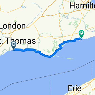
Route from 546 Talbot St, St. Thomas
A cycling route starting in St. Thomas, Ontario, Canada.
Overview
About this route
- 5 h 21 min
- Duration
- 92.8 km
- Distance
- 317 m
- Ascent
- 367 m
- Descent
- 17.4 km/h
- Avg. speed
- 281 m
- Avg. speed
Route quality
Waytypes & surfaces along the route
Waytypes
Busy road
55.4 km
(60 %)
Quiet road
29.1 km
(31 %)
Surfaces
Paved
56.4 km
(61 %)
Unpaved
3 km
(3 %)
Asphalt
40.7 km
(44 %)
Paved (undefined)
15.8 km
(17 %)
Continue with Bikemap
Use, edit, or download this cycling route
You would like to ride Route from 546 Talbot St, St. Thomas or customize it for your own trip? Here is what you can do with this Bikemap route:
Free features
- Save this route as favorite or in collections
- Copy & plan your own version of this route
- Sync your route with Garmin or Wahoo
Premium features
Free trial for 3 days, or one-time payment. More about Bikemap Premium.
- Navigate this route on iOS & Android
- Export a GPX / KML file of this route
- Create your custom printout (try it for free)
- Download this route for offline navigation
Discover more Premium features.
Get Bikemap PremiumFrom our community
Other popular routes starting in St. Thomas
 Bike Hike Strike route 3
- Distance
- 6.1 km
- Ascent
- 79 m
- Descent
- 109 m
- Location
- St. Thomas, Ontario, Canada
 61 Bodkin St, Central Elgin to 56 Bodkin St, Central Elgin
- Distance
- 17.7 km
- Ascent
- 80 m
- Descent
- 79 m
- Location
- St. Thomas, Ontario, Canada
 Relaxed route in St Thomas
- Distance
- 9.4 km
- Ascent
- 33 m
- Descent
- 12 m
- Location
- St. Thomas, Ontario, Canada
 Moderate route in St Thomas
- Distance
- 0.5 km
- Ascent
- 0 m
- Descent
- 0 m
- Location
- St. Thomas, Ontario, Canada
 Snail-like route in St Thomas
- Distance
- 9.4 km
- Ascent
- 126 m
- Descent
- 122 m
- Location
- St. Thomas, Ontario, Canada
 Lake Erie Day 2 - Standley to Selkirk
- Distance
- 134.8 km
- Ascent
- 160 m
- Descent
- 151 m
- Location
- St. Thomas, Ontario, Canada
 Easy ride in St. Thomas
- Distance
- 5.9 km
- Ascent
- 38 m
- Descent
- 35 m
- Location
- St. Thomas, Ontario, Canada
 Peach Tree Boulevard 242, St. Thomas to Peach Tree Boulevard 242, St. Thomas
- Distance
- 10.5 km
- Ascent
- 3 m
- Descent
- 9 m
- Location
- St. Thomas, Ontario, Canada
Open it in the app