

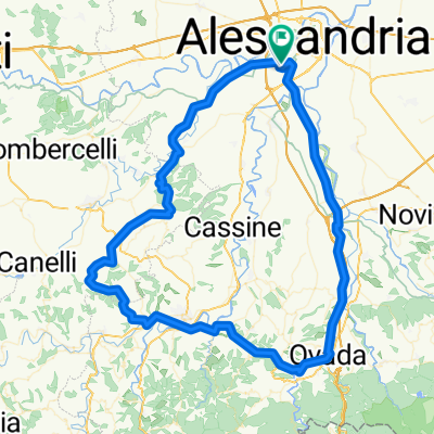
tra alessandria e asti lungo il tanaro
A cycling route starting in Alessandria, Piedmont, Italy.
Overview
About this route
itinerario tra alessandria e asti, costeggiando campi, e strade a basso traffico vicino al fiume tanaro
paesi da visitare villa del foro con il suo forum fulvi romano, oviglio redabue col suo castello, masio con la sua torre
poco dopo roccheta tanaro si attraversa il parco naturale di rocchetta molto interessante, dopo il parco il paesaggio diventa collinare per poi ridiventare pianeggiante dopo la tangenziale di asti
- -:--
- Duration
- 46.2 km
- Distance
- 387 m
- Ascent
- 364 m
- Descent
- ---
- Avg. speed
- ---
- Avg. speed

Route quality
Waytypes & surfaces along the route
Waytypes
Busy road
16.1 km
(35 %)
Quiet road
13.1 km
(28 %)
Surfaces
Paved
10.2 km
(22 %)
Unpaved
1.7 km
(4 %)
Asphalt
9.9 km
(21 %)
Gravel
0.8 km
(2 %)
Continue with Bikemap
Use, edit, or download this cycling route
You would like to ride tra alessandria e asti lungo il tanaro or customize it for your own trip? Here is what you can do with this Bikemap route:
Free features
- Save this route as favorite or in collections
- Copy & plan your own version of this route
- Sync your route with Garmin or Wahoo
Premium features
Free trial for 3 days, or one-time payment. More about Bikemap Premium.
- Navigate this route on iOS & Android
- Export a GPX / KML file of this route
- Create your custom printout (try it for free)
- Download this route for offline navigation
Discover more Premium features.
Get Bikemap PremiumFrom our community
Other popular routes starting in Alessandria
 Da Via Flavio Gioia 11, Alessandria a Via Flavio Gioia 11, Alessandria a Castellazzo Casal Cermelli Casa
- Distance
- 22.6 km
- Ascent
- 41 m
- Descent
- 40 m
- Location
- Alessandria, Piedmont, Italy
 San Salvatore
- Distance
- 13.8 km
- Ascent
- 155 m
- Descent
- 6 m
- Location
- Alessandria, Piedmont, Italy
 Tura Vara
- Distance
- 405.6 km
- Ascent
- 3,963 m
- Descent
- 3,926 m
- Location
- Alessandria, Piedmont, Italy
 AL-OVADA-ACQUI-MOMBAR-OVIGLIO-AL
- Distance
- 103.8 km
- Ascent
- 730 m
- Descent
- 733 m
- Location
- Alessandria, Piedmont, Italy
 sulle strade dei vini
- Distance
- 121.4 km
- Ascent
- 836 m
- Descent
- 833 m
- Location
- Alessandria, Piedmont, Italy
 2016.5 Alessandria - Pavia
- Distance
- 86.6 km
- Ascent
- 105 m
- Descent
- 121 m
- Location
- Alessandria, Piedmont, Italy
 alessandria costa d'ovada alessandria
- Distance
- 138.4 km
- Ascent
- 1,117 m
- Descent
- 1,116 m
- Location
- Alessandria, Piedmont, Italy
 Girolibero: Piemonte
- Distance
- 197.3 km
- Ascent
- 1,283 m
- Descent
- 1,224 m
- Location
- Alessandria, Piedmont, Italy
Open it in the app