

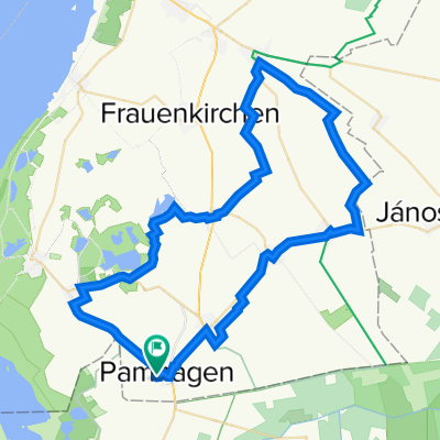
Route nach Rosengasse 4, Wallern im Burgenland
A cycling route starting in Pamhagen, Burgenland, Austria.
Overview
About this route
- 56 min
- Duration
- 11.5 km
- Distance
- 3 m
- Ascent
- 3 m
- Descent
- 12.3 km/h
- Avg. speed
- 119 m
- Avg. speed

Route quality
Waytypes & surfaces along the route
Waytypes
Quiet road
8.9 km
(78 %)
Road
1.1 km
(10 %)
Surfaces
Paved
7.7 km
(67 %)
Asphalt
7.7 km
(67 %)
Undefined
3.8 km
(33 %)
Continue with Bikemap
Use, edit, or download this cycling route
You would like to ride Route nach Rosengasse 4, Wallern im Burgenland or customize it for your own trip? Here is what you can do with this Bikemap route:
Free features
- Save this route as favorite or in collections
- Copy & plan your own version of this route
- Sync your route with Garmin or Wahoo
Premium features
Free trial for 3 days, or one-time payment. More about Bikemap Premium.
- Navigate this route on iOS & Android
- Export a GPX / KML file of this route
- Create your custom printout (try it for free)
- Download this route for offline navigation
Discover more Premium features.
Get Bikemap PremiumFrom our community
Other popular routes starting in Pamhagen
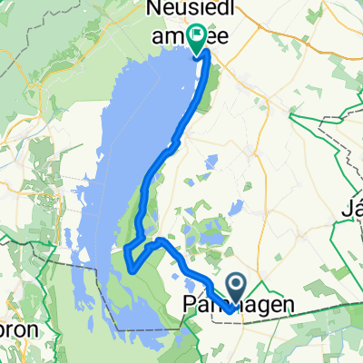
 Neusiedlersee, Lackenradweg, 2. Okt. 2019
- Distance
- 66.4 km
- Ascent
- 22 m
- Descent
- 22 m
- Location
- Pamhagen, Burgenland, Austria
 Lerchenweg 4, Pamhagen nach Lerchenweg 4, Pamhagen
- Distance
- 63.9 km
- Ascent
- 104 m
- Descent
- 103 m
- Location
- Pamhagen, Burgenland, Austria
 Pamhagen Bahnhof - Neusiedlersee Nationalpark Radweg Illmitz - Weiden am See
- Distance
- 41.8 km
- Ascent
- 20 m
- Descent
- 22 m
- Location
- Pamhagen, Burgenland, Austria
 Lerchenweg 7, Pamhagen nach Hauptstraße 7, Bad Tatzmannsdorf
- Distance
- 91.5 km
- Ascent
- 1,112 m
- Descent
- 890 m
- Location
- Pamhagen, Burgenland, Austria
 Neusiedlersee Ostufer
- Distance
- 24.1 km
- Ascent
- 32 m
- Descent
- 37 m
- Location
- Pamhagen, Burgenland, Austria
 "36km"
- Distance
- 36.2 km
- Ascent
- 23 m
- Descent
- 26 m
- Location
- Pamhagen, Burgenland, Austria
 Neusiedlersee - Bodensee (Glockner)
- Distance
- 967.1 km
- Ascent
- 6,713 m
- Descent
- 6,426 m
- Location
- Pamhagen, Burgenland, Austria
 Apetloner Straße 17–33, Pamhagen nach Bahnstraße 52, Pamhagen
- Distance
- 14.1 km
- Ascent
- 3 m
- Descent
- 0 m
- Location
- Pamhagen, Burgenland, Austria
Open it in the app