
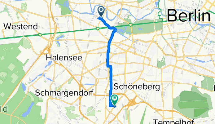
Franklinstraße 28/29, Berlin nach Hauptstraße 80a, Berlin
A cycling route starting in Hansaviertel, Land Berlin, Germany.
Overview
About this route
- 27 min
- Duration
- 6.3 km
- Distance
- 58 m
- Ascent
- 47 m
- Descent
- 13.9 km/h
- Avg. speed
- 57 m
- Avg. speed

Route quality
Waytypes & surfaces along the route
Waytypes
Quiet road
2 km
(32 %)
Pedestrian area
1.3 km
(21 %)
Surfaces
Paved
5.7 km
(89 %)
Unpaved
0.2 km
(4 %)
Asphalt
4.5 km
(71 %)
Paving stones
1.1 km
(18 %)
Continue with Bikemap
Use, edit, or download this cycling route
You would like to ride Franklinstraße 28/29, Berlin nach Hauptstraße 80a, Berlin or customize it for your own trip? Here is what you can do with this Bikemap route:
Free features
- Save this route as favorite or in collections
- Copy & plan your own version of this route
- Sync your route with Garmin or Wahoo
Premium features
Free trial for 3 days, or one-time payment. More about Bikemap Premium.
- Navigate this route on iOS & Android
- Export a GPX / KML file of this route
- Create your custom printout (try it for free)
- Download this route for offline navigation
Discover more Premium features.
Get Bikemap PremiumFrom our community
Other popular routes starting in Hansaviertel
 Berlin monuments tour
- Distance
- 31.3 km
- Ascent
- 79 m
- Descent
- 79 m
- Location
- Hansaviertel, Land Berlin, Germany
 Keithstraße 39, Berlin nach Alter Markt 2, Berlin
- Distance
- 27.9 km
- Ascent
- 264 m
- Descent
- 265 m
- Location
- Hansaviertel, Land Berlin, Germany
 Berlin Sightseeing
- Distance
- 22 km
- Ascent
- 70 m
- Descent
- 70 m
- Location
- Hansaviertel, Land Berlin, Germany
 Rundweg vom Tiergarten zum Tegelersee
- Distance
- 24.4 km
- Ascent
- 37 m
- Descent
- 37 m
- Location
- Hansaviertel, Land Berlin, Germany
 IronRoute
- Distance
- 181.8 km
- Ascent
- 164 m
- Descent
- 163 m
- Location
- Hansaviertel, Land Berlin, Germany
 Höxter - Berlin
- Distance
- 351.9 km
- Ascent
- 513 m
- Descent
- 446 m
- Location
- Hansaviertel, Land Berlin, Germany
 Einsteinufer 20, Berlin nach Kurt-Schumacher-Damm 44, Berlin
- Distance
- 11 km
- Ascent
- 139 m
- Descent
- 141 m
- Location
- Hansaviertel, Land Berlin, Germany
 City-Runde
- Distance
- 20.3 km
- Ascent
- 59 m
- Descent
- 70 m
- Location
- Hansaviertel, Land Berlin, Germany
Open it in the app